The Copper Treaty Demonstrates the Present-Day Impacts of Treaties

On October 4, in 1842, Anishinaabe (Ojibwe) people and American treaty commissioners met on Madeline Island in Lake Superior. They negotiated a treaty that ceded the land along much of Lake Superior’s south shore to the United States, including much of the western half of Michigan’s Upper Peninsula (including the Keweenaw Peninsula) and the most northern regions of Wisconsin. The American government had been eager to control the region’s rich copper and iron deposits since Douglas Houghton’s expeditions in the early 1830s.
Much like the earlier Treaty of St. Peter’s in 1837 (“The Pine Treaty”), the Treaty of La Pointe in 1842 ( which is often referred to as “the Copper Treaty”) legally opened up land to extractive industries. In this case, copper and iron mines were the main industries that developed after the treaty. Logging was also needed to support the mines. For example, lumber was needed to build shafts, heat smelters, and construct the wide range of buildings needed to support the operations. Lumber was also needed as the communities near the mines rapidly.

A map showing Anishinaabe lands ceded in 1836, 1842, and 1854. Map drawn by the author.
While mining brought economic growth to the region, a lot of the mining booms were relatively short-lived: most of the mines were closed by the early 20th century. Many of them never made a profit. The mines also led to significant long-term environmental effects. The waste from mining polluted inland lakes, many of which still have significant heavy metal deposits today, like Torch Lake near Hancock.

A view of the Quincy Dredge at Torch Lake, outside of Hancock, Michigan. Photo by the author.
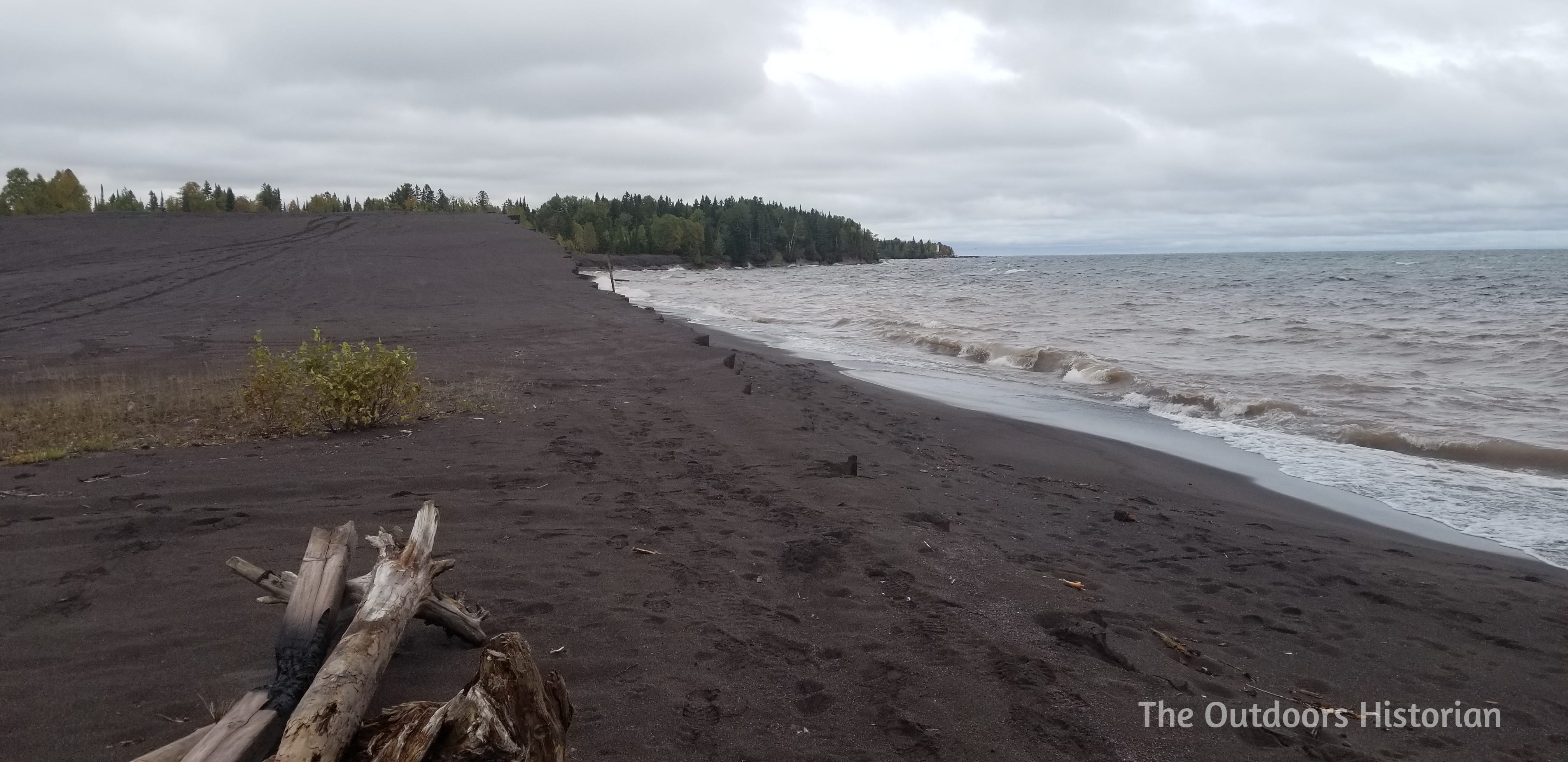
The Wolverine and Mohawk Mills in Gay, Michigan deposited around 25 million tons of tailings, locally known as stamp sands (essentially mining waste) on the shoreline. The rock that was mined contained about 1-2% copper, and the rest of the rock (which became crushed through the process of extracting the copper) was considered waste and discarded. The mills closed in 1932, and since then, the sands have moved along the shore toward the mouth of the Traverse River and gradually replaced the finer white limestone sands of Traverse Bay with the course sticky black sands of Gay. Sands have also migrated north to the Tobacco River.

A view of the vast expanse of stamp sands looking south toward the Traverse River. Photo by the author.
Waves pull the finer sands into the lake, damaging the spawning grounds of lake trout, like the Buffalo Reef, a 2,200 square foot natural cobble feature about twenty miles northeast of Houghton, Michigan. Standing on the shore of the stamp sands, you can feel the immensity of the place. But it’s hard to comprehend that there is also the equivalent of approximately 100,000 railroad cars of Gay stamp sands hidden under the surface of Lake Superior. In total, 1,426 acres of shoreline and lake bottom are covered by stamp sands.
These sands are huge threat to Buffalo reef, which produces approximately 32% of the lake trout and whitefish caught in Keweenaw Bay, and approximately 22% of those species caught along Lake Superior’s southern shore. Stamp sands also affect nearby coastal wetlands: as the sands migrate up the stream, they deposit copper-toxic material in aquatic, amphibian, and plant habitats.
From 2017 to 2021, I brought college students to the Keweenaw Peninsula. The students were part of a program focused on learning about the Lake Superior watershed from interdisciplinary perspectives. We would visit Torch Lake, tour Quincy Mine, visit the Keweenaw National Historical Park Visitor Center in Calumet, and visit the Stamp Sands. At Quincy Mine, student saw the technology first hand and walked tunnels where the miners worked.

A view of the man engine in the shaft house at Quincy Mine, Hancock, Michigan. Photo by the author.
Yet something different happened at the Gay stamp sands. While taking in the landscape, they began to fully understand the immense scale of the copper industry by the sheer amount of waste that it left behind. Here, standing on the shore also means grappling with the legacy of a history of extraction that supported the expansion and growth of the United States (copper was needed for copper wiring for electricity), and created an environmental mess that local communities have dealt with for generations.
A view of the actively eroding shoreline at Gay in 2018. Photo by the author.
Sometimes, our visit to the Gay stamp sands was part of a 3-week long field trip, where we travelled around Lake Superior. Out of all the sites and communities we visited in Wisconsin, Minnesota, Ontario, and Michigan, the stamp sands seemed most symbolic of the cost of an economy grounded in boom-bust industries. This made it a sobering site, but it also provided opportunities to talk about present-day restoration efforts and the work that’s needed to deal with the impact of economies built on over hundred and fifty years of resource extraction.

Students taking in the scale of the stamp sands. This photo is the same view as the last photo but taken a year later, in 2019. The steep eroding edge of the stamp sands has been landscaped to minimize further erosion. Heavy equipment involved in these restoration efforts is visible in the background. Photo by the author.
Interestingly, another site of mining waste in the Lake Superior watershed has become a popular tourist attraction. Black Beach near Silver Bay, Minnesota, is formed by taconite tailings (a similar kind of waste product to stamp sands) deposited by mining companies from the 1950s to the 1970s. Since the beach was opened to the public in 2015, marketing has focused on the beauty of the black sands, and not the environmental impact of mining waste being stored on lakeshores. While the taconite industry no longer deposits their waste on the shores of Lake Superior, Buffalo Reef and the Gay stamp sands are an example of how the impact continues long after the activity ceases.

At Black Beach near Silver Bay Minnesota, I’ve seen people treating it like a beaching—hanging in out the shores. That’s not something I’ve seen at the Gay stamp sands, though I’ve also never visited them on a warm day. Photo by the author.
The Treaty of La Pointe in 1842 also impacts the present in other ways. Like the Treaty of St. Peter’s, Anishinaabe signatories approved the treaty stipulating that they would maintain continued usufructuary rights on ceded land. The second Treaty of La Pointe in 1854, also includes usufructuary rights on ceded territory. The consistency with which these rights are embedded in treaties illustrates their importance to Anishinaabe peoples. County, state, and federal wardens and law enforcement officers ignored these rights for over a century by arresting or fining Anishinaabe peoples exercising their treaty right to hunt, fish, and gather on ceded territory. However, in the final decades of the twentieth century, multiple court cases affirmed these rights, like the Voigt Decision in 1983.
For anyone interested in learning more about treaty rights, Great Lakes Indian Fish and Wildlife Commission has a lot of great material. I particularly enjoy the Ogichidaa Warrior series available on their YouTube (which has a fabulous video on the Buffalo Reef).
Have a question about the Copper Treaty or the impacts of copper mining on the Keweenaw Peninsula? Let me know below!
Meant to say before…fascinating. Thank you.