The Circle Tour Series Part 1: The Intersection of Land, Lake, and Sky in the Minnesota-Ontario Borderlands

Welcome to The Circle Tour Series. In Fall 2024, my partner, Eugene, and I circled Lake Superior. We left our home in Bayfield, Wisconsin, and headed clockwise up the Minnesota North Shore, crossing the border into Ontario. Then we drove along the Ontario shore before crossing the border at Sault Ste. Marie and traveling through the UP, before returning home. Most of our time was spent between Sleeping Giant Provincial Park and Pukaskwa National Park. Part travelogue, part history, this series explores the intersection of industrial ruins, boreal ecology, and personal transition. It is a journey to see how landscapes survive when the systems built upon them including mines, railroads, and careers in higher education, fall apart. This is Part 1 of 6.
Throughout my life, I have lived in the rhythm of the Great Lakes watershed. From the rugged flat-topped diabase mesas of Thunder Bay to the nineteenth century limestone buildings in Kingston to the campus energy of the red-brick expanse of Ann Arbor to the bustling shores of Chicago and the sandstone cliffs of Bayfield. Throughout it all, the lakes have been my compass. I have led students around the Superior Circle Tour and spent over a decade camping in the hidden corners of the U.P. and Northern Wisconsin.
Yet, even for a lifelong resident and historian, there are always gaps. There are stretches of road seen through a windshield but where you haven’t spent sufficient time underfoot or haven’t yet had the chance to explore. For me, that gap was Highway 17 between Thunder Bay and Sault Ste. Marie. I’ve driven the highway about ten times, and I’ve even camped along this stretch. But I’ve never had the chance to truly take my time and explore.
Most people plan the Circle Tour for the height of summer. They cross their fingers for good weather and plan to make the most of the long days. But we have plenty of access to amazing beaches all summer on the South Shore of Wisconsin that are perfect for beating the heat. And because of my previous job as an assistant professor, we could never take long trips in the fall. So in late September, 2024, Eugene and I set out to show that autumn is the secret camping season of the North. The bugs are gone, the nights are crisp, and the lake takes on quickly, shifting moody, vibes you simply do not get in July.


This trip also marked a profound personal transition. Fresh from the heartbreak of losing my faculty position at Northland College—news I received, ironically, while leading students around this very lake—my connection to the water felt severed. For the first time, the lake didn’t offer refuge; it only mirrored my anger.
I needed this journey to find out if the water could still be my source of comfort without the title that had defined me. I needed to return not as a professor, but as a student of the water. Most of all, I needed to remind myself of how landscapes survive when the systems built upon them fall apart. And honestly? I needed a trip that would be fun and on my own schedule.
Refuge and Refuse: A Tale of Two Sands
Eugene and I began by leaving our home near Bayfield, Wisconsin and driving the Minnesota North Shore in a single day. I have driven this stretch countless times since childhood, so the challenge is finding the new within the familiar (with the time that we have available).
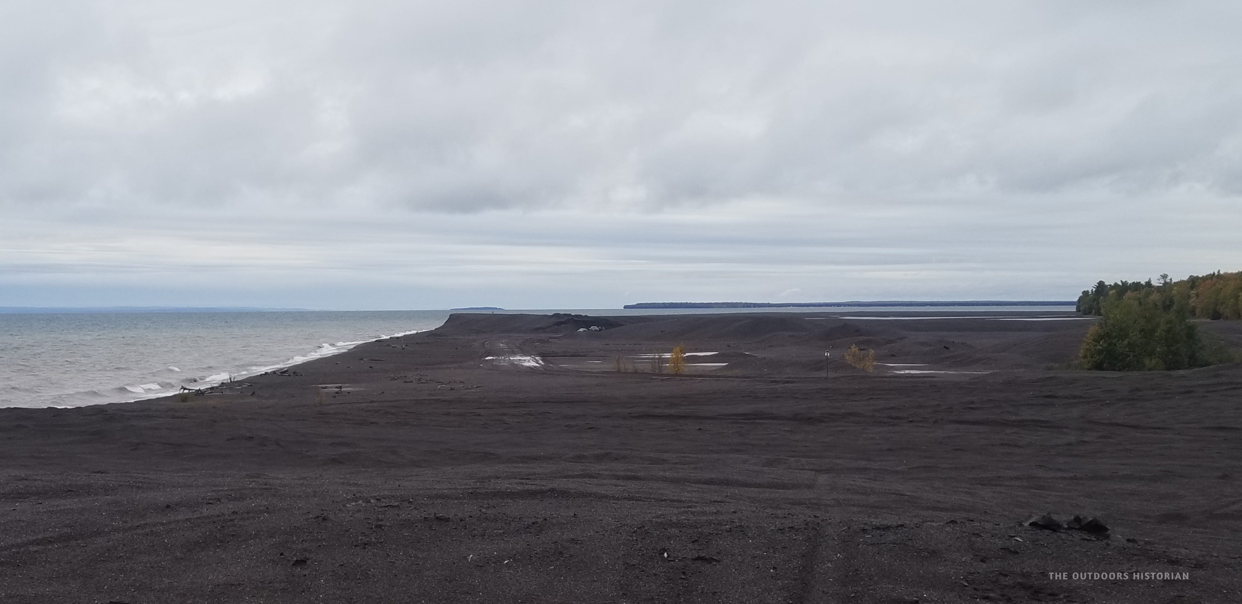
We stopped at Black Beach near Silver Bay for the first time. To the casual tourist, the dark sand is a scenic novelty. To a historian, it is a lesson in the material legacy of extraction. This beach is a man-made landscape formed by taconite (iron) tailings deposited by the Reserve Mining Company. Operating from 1956 to 1987, the company discharged 67,000 tons of waste rock into Lake Superior every day. That is the equivalent of a railroad car every two minutes.

Standing there, I contrasted the landscape with the Gay Stamp Sands on the eastern shore of the Keweenaw Peninsula. I had brought students to Gay several times during my years at Northland College. While Black Beach was created from iron, the sands at Gay are the waste product of copper mining. The scale of the stamps sands at Gay are terrifyingly vast. Over 22 million tons of coarse, dark sand have buried the natural beach and threaten Buffalo Reef, a 2,200-acre natural cobble off the eastern edge of the Keweenaw Peninsula and an important spawning grounds for lake trout and whitefish.
There is a deep irony here. For tourists and residents like myself, the lake is a place of refuge. Yet, as Black Beach and Gay prove, refuse has been foundational to this landscape in the wake of land cession treaties. Whether it is iron on the North Shore or copper in the Keweenaw, the scenes that draw tourists today are often built on the waste of yesterday’s industrial booms.
As we would find later in the trip, the line between waste and wonder is often just a matter of time and perspective.
A Found Manifesto
For me, Grand Marais, Minnesota marks a transition. After the bustling tourist town, Highway 61 gets quieter. Fewer vehicles venture further north toward the Grand Portage Anishinaabe Nation and the Canadian border.
Before crossing the border, we stopped at the Mount Josephine roadside overlook. We stood 400 feet above the water, and I felt like the trip truly began. I read a sign titled, “Land, Lake, Sky. The sign posed the unofficial manifesto for the rest of our trip. It asked: “What pieces of history, of your story, greet you?”
At that moment, I realized that as we moved north, the borders between land, lake, and sky were intensified. Unlike the sandy transitions of the South Shore, here it felt like the ancient rock of the Canadian Shield met the water with a stark precision.

I wonder if this precision is connected to isostatic rebound. While all shores of Lake Superior are rebounding from the crushing weight of the glaciers, the rate varies. The land on the North Shore is rising faster than the South shore. In some places, it rises up to half an inch a year. This slowly tilts the basin and reshapes the coast in a geological slow motion that we can’t see with the naked eye.
Our final stop before crossing the border was High Falls at Grand Portage State Park. The waterfall is on the Pigeon River that forms the international border today. I have visited this site many times, but it never gets old. It is a classic "cap-rock" waterfall where the hard diabase (created by the Midcontinent Rift) sits on top of the much softer 1.85 billion Rove Formation shales.
The hard diabase resisted the river’s path, and created a series of impassable waterfalls and rapids (the Cascades, Middle Falls, and High Falls). For 2,000 years, travelers including the Anishinaabe and the North West Company voyageurs, had to leave the river and carry their canoes 8.5 miles overland to bypass this exact geological “sandwich.”
Looking closely, you can see also see a more recent remnant of history at the falls. There are the remnants of a log flume on the Canadian side. As Canada and the United States worked to strengthen their hold on the region in the late 19th century—following the era of land cession treaties with Anishinaabe people—they targeted the resources of the area. They sought the forests and the minerals buried deep beneath them in the volcanic bedrock.

The Myth of the Wilderness: Re-reading the Borderlands
After we crossed the border, we continued toward my parents’ home in the Whitefish region down the remote Highway 593 (Devon Road).
Returning to my parents’ home in the Whitefish region wasn’t just a logistical stop; it was a chance to reconnect with them and my uncle who was visiting from Colorado. This was a place I spent my summers exploring as a kid and teen. It is a place that shaped my love of the outdoors.
As we followed the Pigeon River and then headed west, we drove deeeper into the boreal forest, crossing the Arrow River a few times and then roughly parallelling the Little Whitefish River. On our route from the border crossing to my parents we were essentially following the reverse route that logs would travel in the Cutover: through Whitefish Lake to the Little Whitefish River to the Arrow River to the Pigeon River.
For many, this drive feels like entering a “remote wilderness,” but my training as a historian has taught me to see it differently. Years ago, while studying under Michael Witgen at the University of Michigan, I read his work, An Infinity of Nations. I’ve reread it countless times since (and if anyone reading has read the entire book more than once, please reach out, because I feel like we’re probably a small a group and should connect!).
An Infinity of Nations fundamentally shifted my perspective. I stopped seeing the western Lake Superior region as a “frontier” and began seeing it as a sophisticated regional hub of Anishinaabe politics and power. While fur trade history often centers on Fort William—where my own paternal family history is rooted—the Anishinaabeg have maintained a complex network of trade, diplomacy, and stewardship throughout the region for centuries.

A Geological Transition
When you travel across the border and along the Devon Road, you also notice a striking difference in the geology. The Minnesota North Shore is mainly defined by the jagged shape of the Sawtooth Mountains. Along the Minnesota-Ontario border stretching northeast through Thunder Bay, the Sibley Peninsula, and Nipigon are flat-topped diabase sill mesas (also known as tablelands). Both of these formations were formed by the Midcontinent Rift, when the continent began trying to rip itself apart 1.1 billion years ago, but their unique stories led to distinctive shapes.
To understand this contrast, we have to look back nearly 1.9 billion years—long before the rift existed. At that time, an ancient sea covered the region, depositing iron-rich sediments that became the Gunflint Formation and a thick stack of flat, brittle shale known as the Rove Formation. Together, these formed a continuous belt of rock. However, when the Midcontinent Rift began to tear the continent apart 800 million years later, it acted like a geological wedge. A massive upwelling of magma—the Duluth Complex—punched through the center of this ancient belt, physically splitting it and pushing the Gunflint Range to the northeast and its sibling, the Mesabi Range, to the southwest.
While both the Sawtooths and the mesas share the same subterranean “plumbing system,” their final forms depended on whether the magma reached the sky or stayed hidden within that older foundation. The Sawtooth Mountains are the remains of extrusive lava flows. Vast blankets of liquid rock erupted onto the surface, stacking miles deep. As the center of the Lake Superior basin sank under this immense weight, the edges of these flows tilted inward toward the lake. Today, when you look at the “teeth” of the Sawtooths, you are seeing the broken, upturned edges of those ancient, leaning lava blankets.

The flat-topped sills of northwestern Ontario never actually saw the sky when they were born. They were intrusive, meaning the magma was injected horizontally into the “pages” of the pre-existing Rove shale. Like water being pumped into a closed book, the magma spread out between the flat sedimentary layers, creating a geological sandwich. Because they were shielded by these level layers, they remained flat rather than tilting.
Over the eons, erosion from wind, water, and ice acted as the great sculptor. In Ontario, the softer shale sitting on top of the sills was stripped away, but the erosion stopped once it hit the cooled, hard diabase. This left behind the iconic mesas of the Thunder Bay region—massive “stone umbrellas” of 1.1-billion-year-old rift rock protecting the 1.9-billion-year-old ancient seabed beneath them.
As Eugene and I drove the winding Devon Road through the mesas and cuestas, eventually we came to its intersection with Highway 588, and we passed the old train station at Silver Mountain. Originally built as a stop on the Port Arthur, Duluth and Western (PADW) Railway, locally known the “Pee Dee” Railroad, it was transformed into a restaurant and bar in the late twentieth century. Now it sits quietly closed. It is a reminder of the industrial past that once shaped this outdoors mecca.

Shadows in the Woods: The Pee Dee
The human history in the Northwestern Ontario borderlands is just as layered as the rock. My own coming of age history is layered on this land.
For decades, this trail has appeared in my life since my childhood. My mom used to ride horses along parts of the Pee Dee, and I’d explore other parts of it on foot with my older brother and our friends (a highlight for us was an old abandoned “army truck”). More recently, , as Eugene and I drove ATVs and vehicles through the backcountry, we were often following or crossing the paths of this old grade.
Built in the late 19th century, the Pee Dee was a small, regional ambition with a specific goal: connect the silver and iron mines of the Gunflint Range to the docks of Port Arthur. But it was operating in the shadow of a much larger reality.
At that time, Port Arthur and Fort William were booming (the two ports were later amalgamated into Thunder Bay in 1970). Following the Confederation of Canada in 1867, the government was desperate to consolidate its hold on the West, and Thunder Bay became the funnel. It received the grain from the prairie provinces to ship east through the Great Lakes to Canadian and American cities with connections to the Atlantic Ocean. From there, the grain could access the world.
This massive nation-building project strengthened Canada, but it did so by dispossessing Indigenous peoples of their lands. In 1885, the government used the unfinished Canadian Pacific Railway (a line aimed to connect the young nation of Canada from east to west) to rush troops westward. Their goal was to crush the North-West Resistance, a fight for rights led by Louis Riel and the Métis people against the rapid encroachment of settlers.
This military victory secured the prairies for the agricultural extraction that would feed the nation, but it came at a devastating human cost: the execution of Riel and the violent imposition of Canadian authority over Indigenous homelands.
The little Pee Dee railroad tried to tap into this bustling port economy by extracting iron from the Gunflint range. But it failed. The mines faltered, the company leadership was corrupt, and the economy shifted. It was a system built on assumptions that no longer held true.
That realization hit close to home. Like the academic world I was leaving, the Pee Dee couldn’t sustain itself against shifting realities. It was a structure built for a boom that had ended. And the leadership didn’t help matters.
Today, the “Pee Dee” is just a shadow in the woods. It serves as a reminder that in the North, the land outlasts plans grounded in unsustainable extraction.

The Place of Thunder
During our time visiting my parents at Whitefish Lake, we spent time in the city itself. This is a place whose very name is rooted in the sky. Thunder Bay is the English translation of the French Baie du Tonnerre, which appeared on 18th-century maps as a translation of the Anishinaabe name. To understand the roots of this name, you must look south to Mount McKay.

Known as Animikii-waajiw (Thunder Mountain), this is the northernmost peak of the Nor’Westers and a sacred site for the Fort William First Nation, a sovereign Ojibwe nation located adjacent to the city of Thunder Bay. In Anishinaabeg tradition, the mountain is the home of the Animikii, or the Thunderbirds. These are powerful spirits of the sky realm who create thunder with the flapping of their wings and lightning with the flash of their eyes.
Today, for a small fee, vehicles can drive up Mount McKay. The mountain itself is a classic example of the flat-topped cuestas and mesas the charactertize the region and it also gives you a stunning, expansive view of the topography that defines the region.
The more adventurous visitors can choose to take a set of trails to different vistas at the top. That is the route Eugene and I took. We took in the even more impressive vista, standing on a 1.1 billion-year-old diabase sill. It is a geological fortress that these sky spirits have chosen for their own. Taking in the brilliant fall colors, I could not help but feel that this was a particularly special meeting of land, water, and sky.
Standing there, I thought back to the sign at Mount Josephine. The history that greeted me here was not just in the rock or the sky or the lake, but in the relationship between all of them.

A Preview of the Future
This was one of many stunning views we would experience. It was also our first time taking in the beauty of the Sleeping Giant on our trip.

In Part 2, we will move from the Minnesota-Ontario borderlands to my first time exploring the Sibley Peninsula, including a discussion of the “world’s richest silver mine,” more multilayered human history, and, of course, great vistas.
Planning your own journey north? As I mentioned, the best parts of the Lake Superior Circle Tour are often hidden in plain sight—like the history behind Black Beach or the secret overlooks on Mount McKay.
I have two ways to help you plan your perfect trip:
The DIY Route: Grab my Free Starter Guide below.
The Expert Route: Overwhelmed by the logistics? Book a 1-Hour Strategy Session to troubleshoot your itinerary with me.
Interested in customized support for your Circle Tour trip? Learn how you can work with me!
Questions about your own Circle Tour or route? Let me know in the comments!
Emily, I love so much that you’ve done this. And your photos are stunning. I’m downstate (a troll!) in Clarkston, about an hour NW of Detroit. Thanks for showcasing our beautiful state. I wish I could appreciate the cold as well as you. I’m shivering at my desk right now. I’m looking forward to adventuring up there vicariously through you! ❤️
Thank you for this post...I've travelled through this area studied it myself as a PhD student. I now write about this area but in short pieces, not a substack post. Your piece reminds me of one I'm writing and another thing published last summer. Thank you