Seasonal Stories: September on the Shipwreck Coast
A Fall Camping Adventure in the Eastern UP

Seasonal Stories is a feature where I share reflections about being outdoors and exploring the northern Great Lakes. Sometimes these posts will mainly be trip reports and other times they may be longer and interweave history and/or memoir (like my post on the Blowdown in July of 1999).
Since leaving academia, I’ve vowed to regularly camp in the fall. Last year, I had a very flexible schedule, so we took about 2 weeks to travel around Lake Superior, focusing on the Ontario shore. This year, I booked a week off of work for the end of the September. Then I asked Eugene, “Where do you want to go?”
I know a lot of people plan their destinations first, but I knew we’d go somewhere within a 8 hour drive and our favorite plans are usually dispersed sites or first come first serve campgrounds. So there isn’t an urgency to nail down the destination. It turns out, here our plans started and where they ended were very different.
First we decided to go visit my parents in northwestern Ontario and go camping on the Canadian side of the Boundary Waters. But then my mom’s plans ended up changing and she was going to be traveling. This was right after we purchased a used Toyota Tacoma.

I scheduled a long weekend trip to see my parents later in the fall and then we thought of other options. We planned a trip to Drummond Island (Michigan) with a friend, planning to camp and explore the offroad trails. Then our friend’s plans changed and as we got to know the Tacoma, we decided we aren’t yet equipped yet to explore Drummond on our own (yet).
So we thought about the amount of time we had, what we were equipped for, and what we wanted to do. And we decided to head to the eastern UP! We drove through this area pretty quickly at the end of our Lake Superior Circle Tour last fall. And other than visits to the Pictured Rocks area with Northland College students, we haven’t explored this area since a quick weekend trip in 2016. We knew there were plenty of back roads to drive and remote beaches to access in this area, and we weren’t disappointed!
Lake Superior’s Shipwreck Coast
The eighty mile stretch of shore between Munising and Whitefish Point in the eastern Upper Peninsula of Michigan is known as the Shipwreck Coast because there are no natural, safe harbors for ships.
Anishinaabe people ceded land in the eastern Upper Peninsula (from the St. Mary’s River to the Chocolay River outside of Marquette) to the United States in 1836. Less than two decades later, the Soo Locks opened. For the first time, vessels larger than a canoe could easily travel between Lake Superior and the lower Great Lakes.
Ships traveling between Whitefish Point and Munising were exposed to strong north and northwest winds that built their force over a distance of 160 miles. Fog was also very common, and the weather could turn quickly (we experienced this first hand). As a result, several life-saving stations were built along the Shipwreck Coast in the second half of the nineteenth century, including Vermillion Point, Crisp Point, Two Heart River, Deer Park (formerly Sucker River Station and Muskallonge Lake Station), and Grand Marais. In total, there were over 270 Life Saving Stations along the coasts of the United States.


The people who worked at these locations worked in the worst storms on the coasts to save lives. A sign on the life saving station at Muskallonge Lake State Park highlights the dangerous nature of the work, quoting “You have to go out, but you don’t have to come back.”

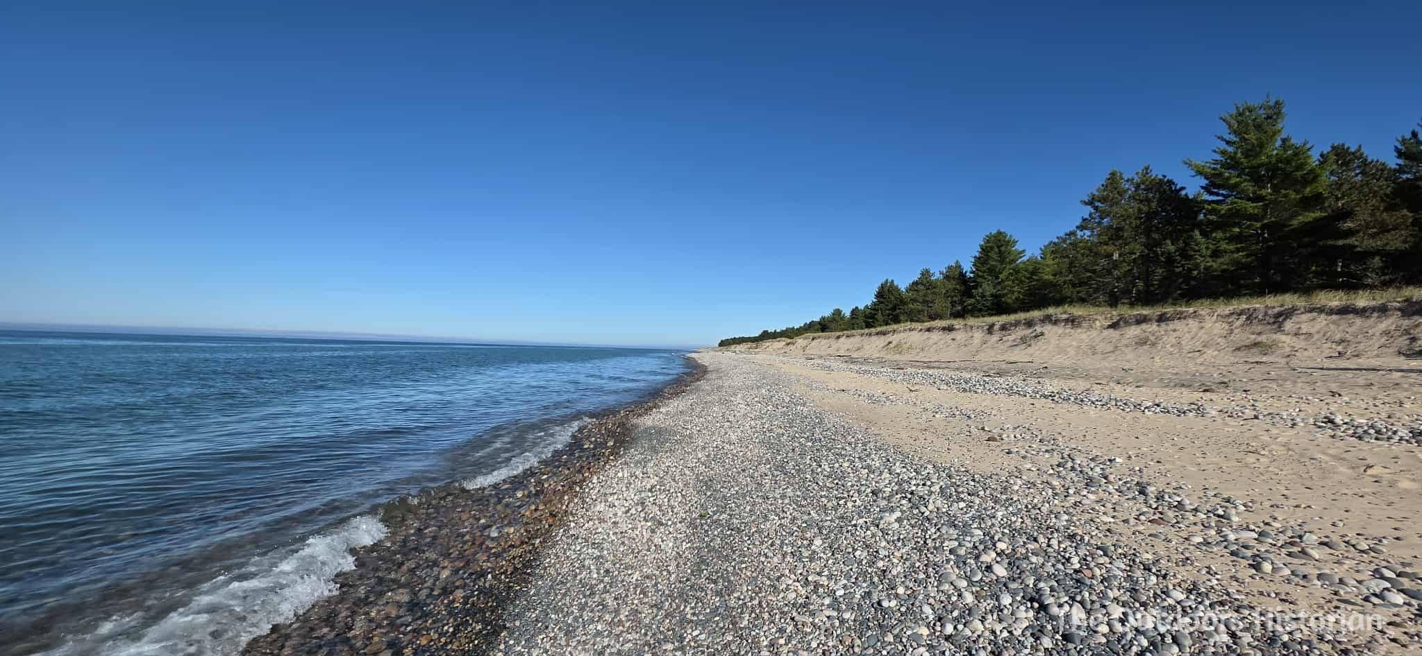
Today, the western half of the Shipwreck Coast is made up of Pictured Rocks National Lakeshore, including the iconic cliffs of sandstone that tower hundreds of feet tall, and Grand Sable Dunes (my favorite dunes in the Great Lakes). The eastern half of this stretch is made up of Lake Superior State Forest, county lands, and private property. Much of the shoreline in the eastern half is made up of low to moderately high, sandy dunes, and wooded bluffs.

Our Journey to the Start of the Shipwreck Coast
We didn’t leave on our trip as early as I had planned. Loading the Tacoma was new to us so it took longer, despite all the prep work that (mainly Eugene) put in. But we got on our way and had an enjoyable drive. We stopped at Meijer in Marquette for some additional supplies. I spent 6 years in Ann Arbor, Michigan, and I fell in love with Meijer during that time (it’s my dream that one opens in Ironwood!).
As we neared Munising, I programed the campground into my phone. I figured we’d take H-58 from Munising to Grand Marais, directly through Pictured Rocks National Lakeshore. Then we’d continue east past Grand Marais and see if there were sites available at Lake Superior Campground. If not, we knew of one nearby dispersed site from a previous trip, and I also knew there were several other state forest campgrounds nearby.
This led to the first snag in our plans. Because I was pretty confident in my knowledge of the area, I hadn’t entered the route into Google in advance. If I had, I would have learned that Grand Marais Truck Trail, which is what we would take to head east of Grand Marais, was closed because they were replacing a culvert at the Blind Sucker River. I wasn’t able to pull up any good or reliable information on a detour through backroads. The only detour on paved roads was long.
It was already later in the day then I had hoped. I began to feel defeated. I knew we could find a site, but we’d be getting there late and with the decreasing daylight hours, we’d probably be setting up in the dark. It might not be a great site, and chances are, we’d just decide to try and find a new site the next day. It seemed like a lot of effort for potentially low returns. I shared my concerns with Eugene. He agreed and we decided to adjust our plans and find a motel room in Munising for the night.

We stayed at Sunset Motel on the Bay and had a beautiful view of Munising Bay. But, the highlight of the evening was going to East Channel Brewing Company and getting a delicious pizza from The Cooking Carberry’s Wood Fired Pizza and Catering. I didn’t get pictures, but the blueberry pizza was SO GOOD! And I come from a family that makes amazing pizzas so I have pretty high pizza standards. And the seating area is super cute. We also ended up having a lovely conversation with the staff and another couple from western Minnesota, who had also visited the Apostle Islands (near where we live) and Mackinac Island. It was fun to hear how, out of all their travels, they particularly enjoyed the Apostles!
Overall, it was a lovely evening! And it getting to Lake Superior Campground early the next day turned out to be a big benefit!
A Premier Site at Lake Superior Campground
In the morning, we headed to Falling Rock Cafe and Bookstore for lattes and breakfast. Of course, I also had to buy a few books. I just can’t resist a good bookstore! Then we headed to the campground.
If you haven’t visited Lake Superior Campground before, it’s a rustic, state forest campground with about 20 sites. Now, generally, we find national forest campgrounds tend to have nicer sites than state forest campgrounds in Michigan. But, this is one of the nicest state forest campgrounds we’ve found. Most of the sites are nestled behind a small bluff on Lake Superior. I don’t think the sites are quite as nice as Twelvemile Beach Campground in Pictured Rocks, but Twelvemile books up so quickly and you have to work so hard to get a reservation. As a result, it doesn’t really fit our current camping travel style.

When we arrived at Lake Superior Campground, the first few sites were full. I got a bit nervous. Then we saw an empty site. I’d describe it as decent. . . there’s better sites in the campground, but there’s also worse sites. We like privacy, so my least favorite sites are the open ones by the self-registration and water pump. Sure enough, we kept driving, and one of those sites was also open. As we continued down the road, we saw more full sites.
Just as we were planning to go back to the first empty site, we saw it. A beautiful, spacious site. One of the best in the campground. And it was vacant. We quickly pulled in and claimed it as ours. As we wandered around and took in the view of the lake, I felt myself relaxing. We also noticed there were still warm coals in the fire pit. The previous occupants had left just before our arrival. We lucked out.

Most of the afternoon was spent setting up camp. After we got our tent set up, we noticed some dark clouds in the distance and Eugene decided to set up a tarp over our “kitchen” area. This turned out to be a great plan. About fifteen minutes after he finished setting up the tarp, it started to rain. The intensity quickly increased. Soon it was pouring.
This led to the second challenge of our trip. It was a great site, but some of it’s privacy comes from being in a low spot tucked behind a dune. Each of the neighboring sites was higher than our site. And we had set our tent up in one of the flatter spots, but it was also near the low point.
To be honest, I had thought of the topography as we started setting up the tent. And I had seen a chance of showers in the forecast, but I hadn’t really thought they would be heavy rains. And I didn’t see any other level spots that would be good for our tent, so I hadn’t mentioned it to Eugene.

Now, we were sitting on our chances under the tarp, watching the water rush in small rivers toward our tent at the low spot. I wish I had thought to take a picture or video, but after zipping up the windows, and making sure nothing was on the mat that we use over the ground (our tent has no floor), we left our phones in the tent.
“I didn’t even think about the tent being in the low spot,” remarked Eugene.
I sighed. “I thought about it but didn’t bother to mention it. I didn’t think it would rain this hard and it seemed like the best spot to have a view.”
Eugene pointed out how we could have shifted the picnic table and the Tacoma and had other options for the tent. Okay, noted. Next time, I’ll raise my concerns rather than put them to the side.
Luckily, it wasn’t a long rain, and the sandy soils quick absorbed the puddles of water the had formed around our tent. It was a short-term inconvenience (and a good lesson), but it didn’t cause any long-term issues. We spent the rest of the night around a fire and making philly cheesesteaks before heading to bed.

From Grand Marais to Deer Park
We learned from a neighbor at our campground that there a six mile backroads detour to Grand Marais. So after we got up and ready to go, we decided to head into Grand Marais, and top of with gas. At the gas station, a man complimented us on the Tacoma and said they’ve driven from the Twin Cities to the eastern UP and this was the coolest rig they’ve seen! He was also disappointed to learn that while the gas station sells a range of useful items, it is not a dispensary and there is no dispensary in Grand Marais.
Then we headed to the Dream Bean for lattes and some spontaneous gifts for myself, including a press for drying flowers/leaves and watercolor pencils in a lovely canvas case. Eugene loves maple lattes, so when there’s opportunities to get them on camping trips, we tend to jump on it.

On our back to the campground, we drove a additional backroads. At first, we hit dead ends or private property, but as we got closer to the campground, we found the first of several great dispersed camping spots.
Back at the campsite, we had a quick light lunch (cold cuts, cheese, crackers, and other snacks) and decided to head out again. First, we checked out a dispersed site we were familiar with from driving through the area in 2019. We were glad to see it was still accessible, and that no one was there. We spent a few minutes on the beach, then we continued further east.
This led to one of my favorite experiences of the trip: we drove by Ugly Fish Baking Company in Deer Park and decided to stop in. I was familiar with Ugly Fish because I had read two books by the owner, Ellen Airgood (South of Superior and Tin Camp Road). But as we planned this trip, I hadn’t put the pieces together on just how close our campground was to Ugly Fish! We got maple lattes, whitefish chowder for a snack, and sweet treats for later.

This was the first of many stops that we made. But we couldn’t help it, because the the drinks and food were so good, and their hours were so convenient. Most days of our trip they were open from 9 am to 7 pm. If no one is at the trailer, you hit a call button on a walkie talkie. Someone responds letting you know they will be there soon. A few minutes later, someone will bike down the driveway and hop into the trailer and get you whatever you’d like. We tried a lot of baking and it’s hard to choose favorites. Eugene was a big fan of the banana bread, and I loved the brownie (so fudgey and chocolatey!). We also had a great cinnamon roll and several delicious cookies. The maple walnut bar was also delicious, but very very rich.
After this fun stop, we continued east, drive dirt roads and two-tracks. We found a few more campsites and took a short hike on the North County Trail.

We got back to the campsite fairly late, around 7:30 pm. We made a fire, but we weren’t very hungry after our hearty late afternoon snack at Ugly Fish. So we just snacked more. After a short, enjoyable but unsuccessful walk along the beach looking for Yooperlites, we went to bed.
Toward the Mouth of the Two Hearted River
On our second full day camping on our September trip at Lake Superior Campground, we began with getting lattes and baking from Ugly Fish. Then, we spent the day driving back roads from our campground to the west side of the Mouth of the Two Hearted River.

We found a few decent dispersed sites early on, and continued our exploration and came to a small spot on the edge of a steep sand dune overlooking Lake Superior. There was erosion at the top and it was quite vertical for about 5 feet. There was a rope ladder at the top to get down this part. Then there were a few trees to create a small flatter spot, and then it descended sharply to the beach. I looked at, took in the beauty, and then told Eugene, “I’m not going down that.”
Eugene got closer to the edge than me. He took a more thorough look at the beach. “Are you sure?” he said.
“Why? Did you see a big agate?” I joked. It’s a running joke we have when we are looking at a rocky beach that’s not easy to get to.
He laughed, but then got serious. “Not an agate, but I think you will want to go down.” He pointed out a pile of garbage, mainly plastic, off to the side.
I sighed. I hadn’t noticed it before he pointed it out. We had committed to trying to pick up the plastic garbage we found. So far we had found several balloons and glow sticks. The pile at the bottom was bigger than everything we’d picked up so far that day.
“Let me check to see if it’s safe.” Eugene investigated the ladder and checked it for safety. He determined it was good to go both in terms of safety and my skill level. So we decided to go down--he said he’d carry the garbage back-up.
We made the descent down the dune. This was the easy part. Once we got to the beach, we looked around. We didn’t see any other people in either direction. We’d been to some fairly remote sites, but in the distance we’d often see a rock hunter or two. But in this stretch, we were all alone.

We walked to the water’s edge and began looking at rocks. Now, I’m going to be honest: I’m a lazy rock hunter. I believe if an agate or a Yooperlite or some other desirable rock wants to present itself, it will. Most of the agates I’ve found have been within my first 20 minutes at a location. However, most of the time we hang out at a location for 15 minutes, point out some pretty rocks, then move on. I used to collect a lot, but now I try to be more selective because I have a bunch of random jars of pretty rocks at home that I haven’t done anything with. But occasionally, within that search, we find something really cool.
In this case, I found an agate within the first couple of minutes. Agates are rare enough that finding one always feels special to me. In this case, it felt like a gift from the lake for our willing to climb a dune to pick up a plastic.

True to form, we looked for another 15 minutes or so. We found a few other rocks we liked and that I decided to put in my pocket. But no other agates. Then we enjoyed the beach for a few minutes. And then, kind of reluctantly because it was such a peaceful spot, we decided to get moving because there was a lot more exploring we wanted to do. So we picked up plastic and then made the tiring climb up the dune.
When we got to the top, the clouds cleared and the sun came out. It was the first time we’d seen the sun that day, and it felt like another gift from the lake.

We continued on and found a tall dune to climb. This one was inland and less vertical, although overall it was higher. It made for a great overlook of the nearby area which was burned by the Duck Lake Fire from 2012.
Eventually made it as far as you can legally get with a vehicle toward the west side of the Mouth of the Two Hearted River. We climbed to the top of the dune at the turnaround for an overview of the area. On our drive back to the campground, we took a few different side roads and found a beautiful overlook of the river.

Eugene wanted another latte, so we stopped at Ugly Fish. I got an iced tea because it was too late in the day for a latte for me. Then we headed back to the campsite and transitioned to drinking beer. I made a southwestern-spiced cheesy ground beef and rice dish for dinner. We gave Yooperlite hunting another try and we found two small ones fairly quickly. Then, we hit another dry spell. We decided the two ones were just luck and decided to head back to the campsite.

From the Two Hearted River to Crisp Point Lighthouse
For our final, full day, we explored between the Mouth of the Two Hearted River and Crisp Point Lighthouse. Once again, we began the day at Ugly Fish. I wasn’t joking when I said we became frequent visitors!
It was an interesting stretch because at the Mouth of the Two Hearted, you are in the midst of the Duck Lake Fire from 2012 that burned over 21,000 acres. And for the first few miles of driving, you are driving through the remnants of the burned forest. Then, after you get east of the Mouth of the Little Two Hearted River, you are back in mature forest.

This stretch started with gradual dunes and then transitioned to a vegetated bank. While that made for less dramatic views than the previous day, it also meant easier water access for the dispersed sites. We came to a really great site toward the end of the day. Probably the best we’ve found all trip in terms. Then we continued and the final site we found was even better! Definitely our favorite that we found all trip. It was a spacious site with lots of mature trees on the side of a low bank and a gorgeous stretch of beach that looks like lots of fun for rock hunting. It’s one of the nicest spots we’ve found in terms of spaciousness, privacy, and beach access, and we are really looking forward to returning to camp there in the future!
After finding the final two campsites, we made a quick stop at Crisp Point Lighthouse, which was built in 1875. The following year, it began operating as Life Saving Station Number Ten, of the U.S. Life-Saving Service District 10 (later part of District 11). It is named after one of the Life Saving Station keepers, Christopher Crisp and was integrated into the United States Coast Guard in 1915 (along with the rest of the United States Life-Saving Service).

Then we headed back to the campsite for a delicious steak dinner. It was a great way to wrap-up our explorations! The wind picked up and there were some decent waves, so we decided to try Yooperlite hunting again. But the waves made it difficult to get to close to the shore where the fresh rocks were getting churned up, so we decided just to call it a night.
The night day we got up and got to see some amazing waves. On days like this, Lake Superior really feels like an ocean. We packed up, made a final stop at Ugly Fish, and headed home. And yes, we stopped at Meijer again too.

Choose Your Own Adventure on the Shipwreck Coast
I must say, the UP has some absolutely amazing dispersed sites directly on the Big Lake. There are the well-known dispersed sites that are so popular I don’t mind naming them (like Mouth of the Huron River and High Rock Bay). However, there’s also a lot of lesser known ones on state land that we’ve found between the Keweenaw Peninsula and Crisp Point.
A lot of the sites we found this trip along the Shipwreck Coast require the right kind of vehicle to access them comfortably. There’s both some fairly bumpy/rough roads, and sometimes, some narrow roads to access the sites. We had no issue in our Tacoma, but some of the spots would be a struggle with our Tundra, due to the size. And while we did take my old Rav4 down Two Hearted Landing Road once when I was in grad school, we definitely were not comfortable (or stupid) enough to try any of the side tracks that access the lake.

Keep in mind, there’s also substantial sections of shore where you won’t find any dispersed sites because of city development, private property (whether it’s individual parcels or one large parcel like the Huron Mountain Club), or highly regulated public lands (like Pictured Rocks National Lakeshore). So you need to do some research advance. But if you scout out areas with state land and you have the right vehicle, there’s a lot of gems! Especially if you like camping near beaches.
Of course, even if you don’t have a vehicle that can make it to the trickier dispersed sites, you still have a lot of options. You stay in Munising or Grand Marais if you want lodging a hotel or motel or vacation rental. If you like campgrounds with electric at the sites and bathrooms, you can book a site at Muskallonge Lake State Park (which was closed for renovations during our trip). There’s also municipal campgrounds in Munising and Grand Marais. If you book far enough in advance, you can book a site in Pictured Rocks National Lakeshore at Beaver Lake, Hurricane River, or Twelvemile Beach. If you like rustic campgrounds, you can try and snag a site at Lake Superior Campground, or go to one of the nearby Blind Sucker campgrounds. There’s also more state forest campgrounds past Deer Park.

If you like tours and structured activities, you’ll want to focus on the western (Pictured Rocks National Lakeshore) half of the Shipwreck Coast. In the eastern half, there’s a museum at Whitefish Point and (depending on the season and hours) tours of the lighthouse at Crisp Point, but otherwise, it’s mainly self-guided sites and off the beaten-path exploring.
Originally, we had planned to use the Lake Superior Campground location to revisit some area of Pictured Rocks and explore further east. But with the detour on the Grand Marais Truck Trail, Ugly Fish providing Eugene with his latte fix, and our new Tacoma, we decided to just focus on exploring the eastern half. And it was a blast! We will definitely be returning.

Do you have a favorite camping spot in the eastern UP? Feel free to share it below!
Loved the arm-chair tour and next time I’m up there I want to try that blueberry pizza. And snag another agate.