Seasonal Stories: Exploring Fall Colors By Day, Hunting for Fire at Night
Glowing Stones, Offroad Adventure Over Ancient Rocks, and the Ghosts of the Keweenaw Peninsula

Seasonal Stories is a feature where I share reflections about being outdoors and exploring the northern Great Lakes. Sometimes these posts will mainly be trip reports and other times they may be longer and interweave history and/or memoir (like today or my post on the Blowdown in July of 1999).
As we drove north up the Keweenaw Peninsula in mid-October, there was a strong northwest wind blowing off Lake Superior. It cut sharp, a reminder of the more hazardous weather that was soon to come with the Gales of November.
On a practical level, we came to the Keweenaw Peninsula to test our still-fairly-new-to-us Toyota Tacoma. But we were also in search of many kinds of magic that you can’t find just anywhere. Stones that glow like embers in the dark. A campsite tucked away from the world. The brilliance of peak fall colors, and what feels like endless possibilities of exploration.
History was not the point of our trip. But you also cannot explore the Keweenaw without stumbling over its ghosts. This rugged peninsula that juts into the largest freshwater lake in the world, holds layers of stories from ancient Indigenous miners, fur traders, Anishinaabe peoples, and a diverse range of boom-town immigrants around the turn of the twentieth century. I also have my own ghosts tied to this place, but those are stories for another time.

Before the Journey
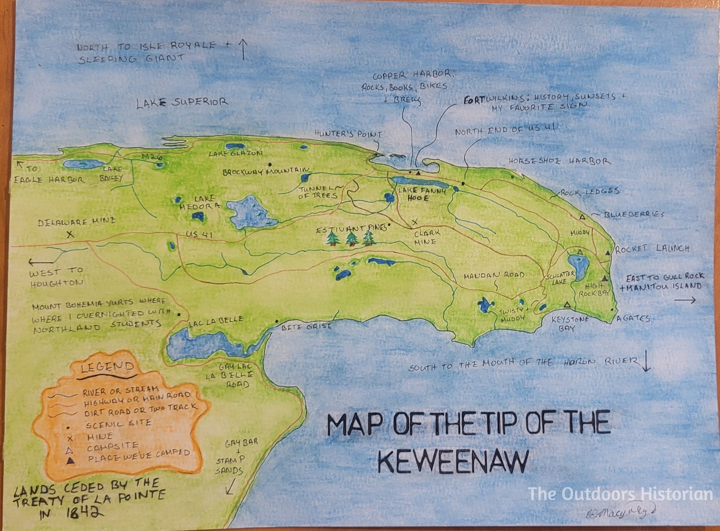
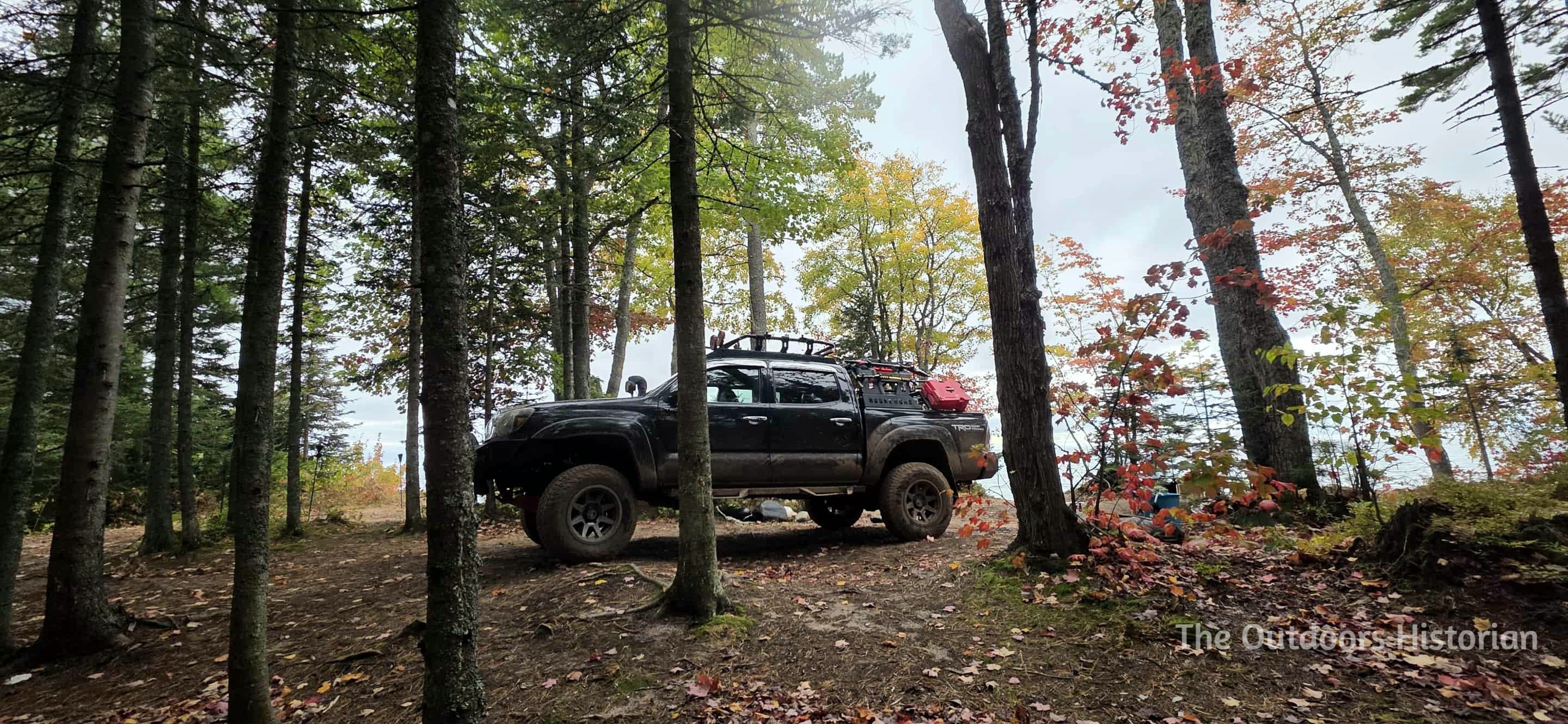
Eugene and I have made several visits to the Keweenaw Peninsula since my first trip over eight years ago. I have brought students to the area on about half a dozen trips, and we have also made about half a dozen personal trips. For the latter, our favorite way to explore is dispersed camping. We have camped at High Rock Bay and the Rocket Range in the past. This time we wanted to go to Keystone Bay, an area we stumbled upon once when driving trails in the region in 2020. It is hard to access with most full-size vehicles because of the narrow, muddy, twisty two-track to get there. Now, with our recently purchased 2013 Tacoma, we were confident we could visit again.

But before we could go looking for magic in a land shaped by ghosts of the past, we had to deal with a problem in the present. Our timeline for our departure day was tight. We were getting new rear shocks on our Tacoma, and the mechanic who handles alignments had called in sick on Thursday. We had to wait until Friday morning to pick up the truck. I hovered on the edge of postponing the whole thing to the following weekend, but the weather forecast was too perfect to waste, the fall colors were peaking, and Eugene was motivated.
So, we got up early on Friday morning and drove the fifty-mile round trip to the mechanic to retrieve the truck. We made a quick stop at a grocery store for last-minute supplies. Luckily, Eugene had developed an efficient packing system using interlocking Makita cases, so once we had the Tacoma at home, we were soon ready to get on the move, test out the new shocks, and compare them to what we felt on our September trip to the eastern UP.
The irony was that despite our productive early morning we did not officially get on the road until noon. And the questions nagging at us were practical: Did we remember the correct route to Keystone Bay? Would we have enough daylight to set up camp?
Traveling Backwards Through Time
The Keweenaw was formed by geologic events over a billion years ago when the continent tried to rip itself apart (known as the Mid-Continent Rift), causing massive flows of lava to erupt, forming thick of volcanic rock that underlie much of the current lake basin. Eventually, the lave stopped spewing out, but the weight of the layers caused the rift’s center to sag, and the ends to life and tilt, exposing the deposits of volcanic activity.

Since the ice retreated over 10,000 years ago, people have been drawn to the Peninsula for its rich copper veins. Indigenous peoples mined deposits of pure copper in pit mines along the surface. Usually, copper binds with sulfur to form ores like chalcopyrite. But the low-sulfur environment where these basalts formed meant the copper remained in the form of pure, native copper. In the late-nineteenth and early twentieth century, miners from a range ethnicities including Cornish, Polish, Italian, and Finnish, dug deep shafts, following the angles of the volcanic layers formed during the Mid-Continent rift to access copper deposits.
In the present-day, going to the Keweenaw requires intentionality. It is not a place you tend to stumble across. Copper Harbor is the northernmost point of the Upper Peninsula of Michigan (Isle Royal National Park—an island in Lake Superior, is the most northern point of the state). If you are traveling directly across the Upper Peninsula of Michigan, there is no need to travel into the Keweenaw. You are not going to accidentally end up at Copper Harbor on a road trip to another destination. The northern beginning of US-41 is just past small mining community turned tourist town—the pavement ends here.

While many visitors cross the Mackinac Bridge to reach the Keweenaw, we approach from the west, driving through the dense canopy of the Ottawa National Forest until we hit the rocky curved spine of the peninsula. On this trip, the fall colors danced before us. Vibrant yellows and oranges interspersed with occasional reds beckoned us, each turn revealing a new canvas painted by nature.

As we drove across the landscape, I thought about the Anishinaabe people who have stewarded these lands and waterways for centuries. I also reflected on the Anishinaabe name for this place: Gakiiwe-wewaning, which means “where a portage is made” and “the crossing place.” We were relying on our truck’s new suspension to navigate the tip of the peninsula, but for millennia, waterways were the most efficient way to travel across this region. Miles off the coast of the tip of the peninsula are Gull Island and Manitou Island. Together the Peninsula, the islands, the rocky shoals around them, and intense winds create strong currents. So, while navigation by waterways can be efficient, it can also be very treacherous.
Enjoy what you are reading? I’d be grateful if you’d consider sharing my Substack with other people who love history, the out doors, and the Great Lakes!
To avoid the most dangerous waters, when Indigenous peoples were traveling along the south shore of Gichigamiing, the Anishinaabe name for Lake Superior, they usually cut across the center of the Peninsula along a series of lakes and portages. They used these routes long before French fur traders and missionaries arrived in the late seventeenth-century.
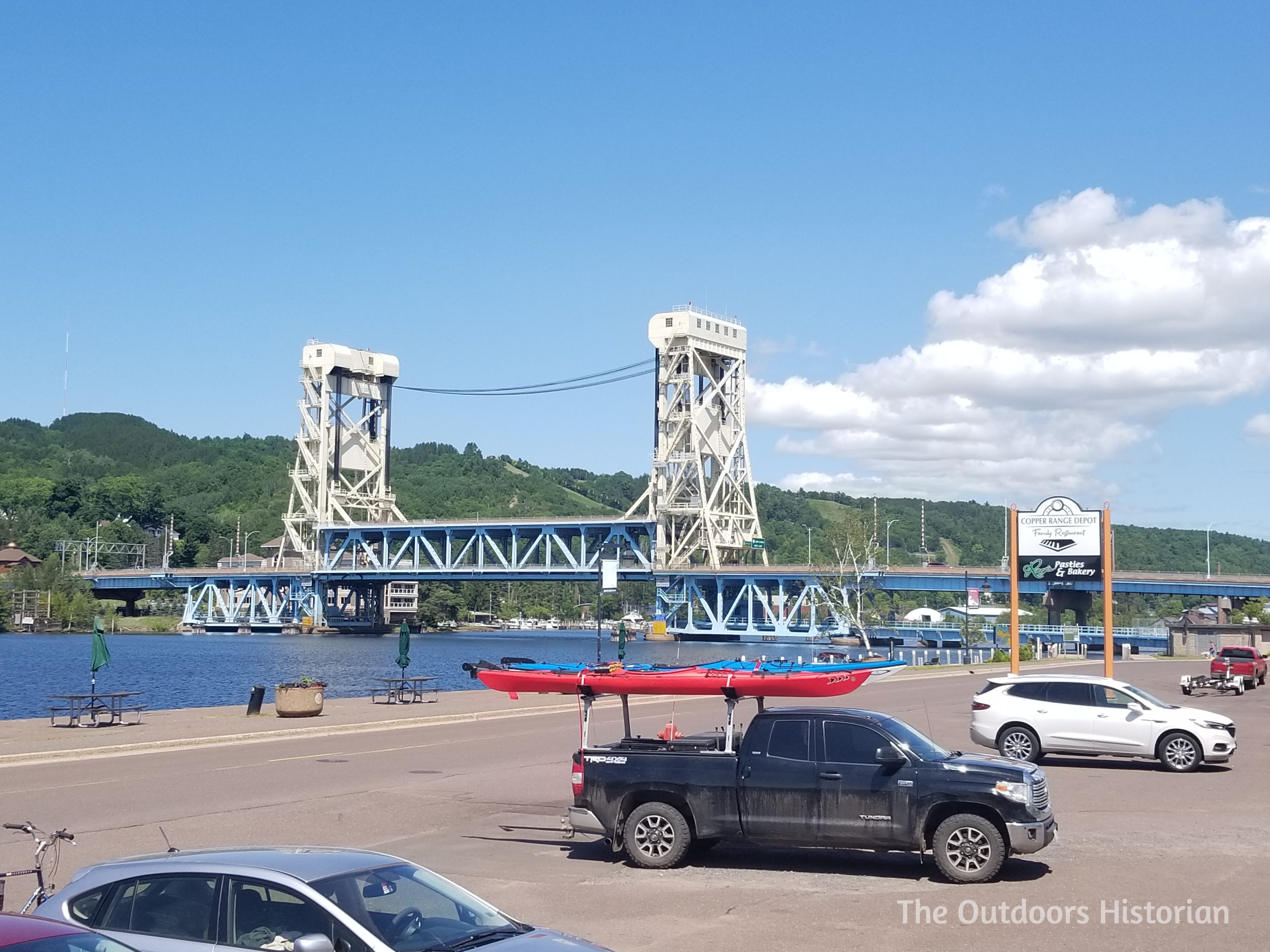
In the Civil War era, this route was transformed into the Keweenaw Waterway (commonly referred to as the Portage Canal): a series of canals that allow ships to cut across the Peninsula. The first section was completed in 1860, and the last section was completed in 1873. Like most visitors, we crossed the Keweenaw Waterway on the Houghton Lift Bridge, which links the cities of Houghton and Hancock.
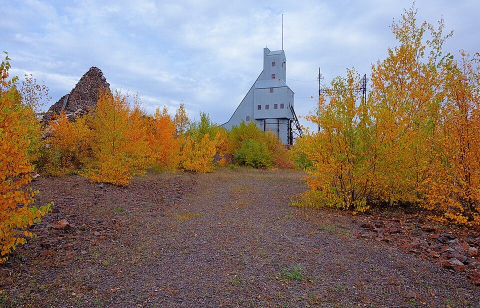
As you climb up the hill through Hancock, the Quincy Mine Hoist House appears, towering across the landscape. This is just one example you see that remind you of the copper boom that exploded in the area after the United States acquired the Keweenaw and the rest of the western south shore of Lake Superior in 1842 by signing a land cession treaty with Anishinaabe peoples. This treaty was signed after Douglas Houghton led an expedition in the area, identifying the potential for mining copper and other metals, like iron. While this treaty ceded land to the United States, it was not a removal treaty--Anishinaabe people remained in the region. In 1854, the United States signed another treaty with Anishinaabe people and created a created reservation at Keweenaw Bay. Both treaties recognized Anishinaabe peoples ongoing usufructuary rights, or in other words, their right to continue to hunt, fish, and gather on ceded territory.
We stopped for gas in Calumet and continued on US-41, which winds its way up the Keweenaw, following a series of ridges that make up the peninsula’s bony spine. After a series of curves through a tunnel of colorful canopy of leaves, the driver took us by the Keweenaw Mountain Lodge, and we descended a hill and entered the small tourist town of Copper Harbor.
I love Copper Harbor. It is one of my favorite small towns on the Lake Superior Circle Tour, but we did not have a reason to stop at that moment, and we were on a time crunch. The questions from earlier continued to echo in our heads: Did we remember the correct route to Keystone Bay? Would we have enough daylight to set up camp?
A few miles later, we passed Fort Wilkins. Now a state park, the United States military built the fort in 1844, because of American’s fears of Anishinaabe peoples attacking the newly established copper mining communities. These fears were based on the racism and fear of American officials who misunderstood Anishinaabe people, rather than any basis in reality. Later, the fort housed soldiers waiting for the end of their enlistments after the Civil War.
Not far past Fort Wilkins, the pavement ends at the end of US-41. Our route continued on the gravel and dirt logging roads that extended out in maze. Logging operations started after the U.S. acquired the land in 1842 to feed the timber demands of the mines. Today, logging continues to be an important industry in the region, and as you continue past Copper Harbor off pavement, logging trucks or other signs of active operations are a common sight.

Sanctuary Along the Shore
Having traced the peninsula’s rich history, we were eager to immerse ourselves in its present beauty. By the time our tires hit the turn-off to the narrow two-track leading toward Keystone Bay, we drove through the quiet aftermath of all that industry. Now, the main questions that had nagged us in the driveway—did we remember the route? Will we arrive before sunset? – were finally answered.
We made one wrong turn, hitting a dead end causing us to backtrack and try another route, which had a shallow water crossing. The terrain suddenly looked familiar. “I remember this,” I told Eugene. “We’ve been here before.’” After many tight turns and some mud, which we both remembered, we rolled into Keystone Bay with just enough daylight to spare.

The contrast was immediate. While high winds whipped up the lake at Copper Harbor, Keystone Bay felt like a secret held close by the land. Tucked away south of the peninsula’s tip, the bay was sheltered from the wind and the water calm.
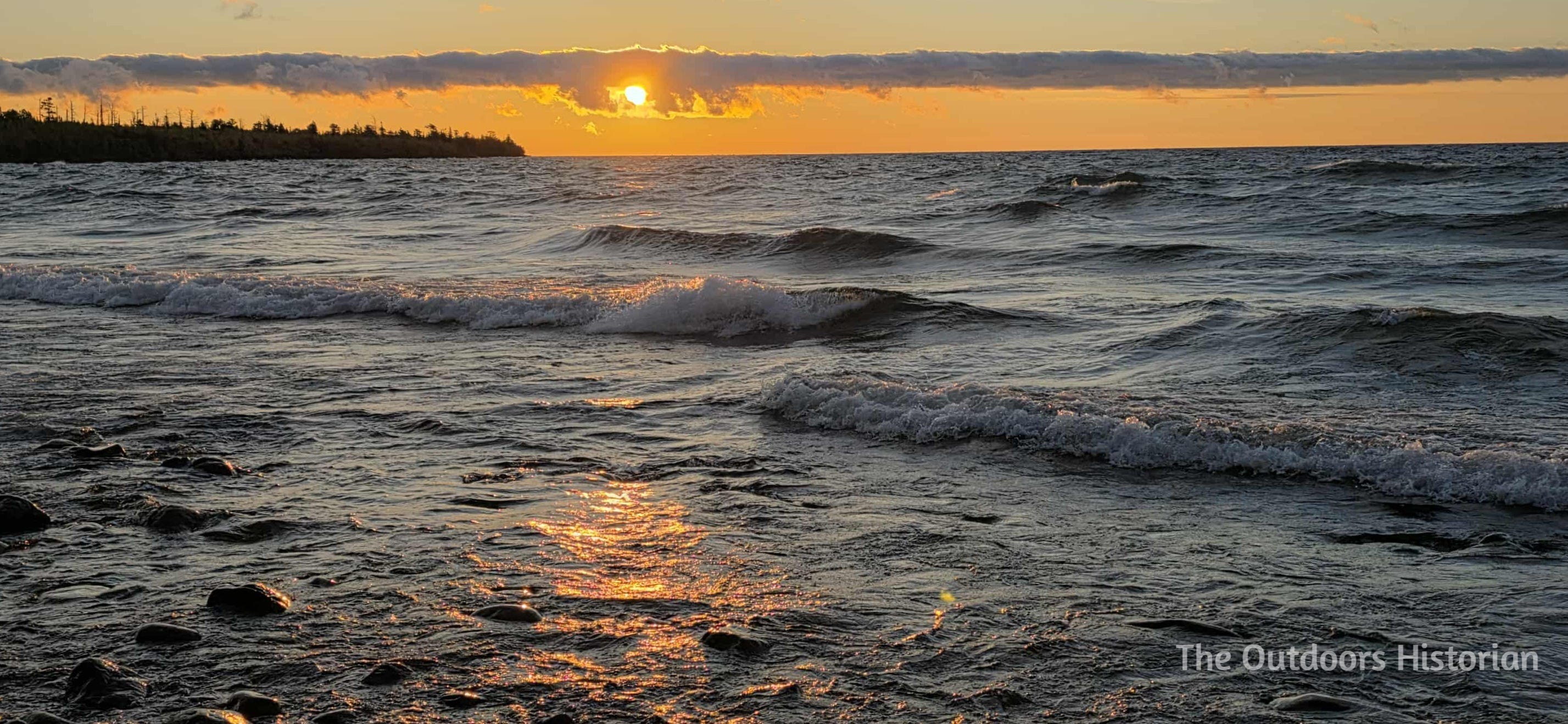
We set up camp in the fading light, soaking in the peaceful sunset and establishing our temporary home in this special place.

As we lit the tiki torches, the solitude was briefly, and pleasantly, interrupted. A husband and wife pulled up in an SXS, their engine cutting through the quiet. They were not just passing through; they were returning from a hunt. They showed us their haul; they had filled the back of their buggy with “Yooperlites,” aka fluorescent sodalite. To the naked eye, the rocks blend in with a million other grey stones on the beach, but they hold a fiery secret. Under a UV beam, they erupt with a bright orange glow, looking for all the world like embers that refuse to cool.

We have casually hunted Yooperlites since 2019, and we had brought our UV flashlight on this trip. We knew Keystone Bay was sandy, but we hoped we would find some rocky areas of the shore to hunt at either end of the bay.

As luck would have it, the couple generously offered us tips on where to look in this specific area. They also complimented our site, mentioning they wished they were staying the night. It was a brief intersection of lives, a reminder that even in the remote corners of the Keweenaw, there is a shared camaraderie among those willing to make the trek.

With the tent pitched and the visitors gone, we turned to the second priority of the trip: dinner.
Our philosophy on camping food is that “roughing it” should not apply to the menu. We made campfire fajitas—a system I have perfected. I had prepped and seasoned the thinly sliced chicken, bell peppers, and red onion at home, so they hit the pan ready to sizzle.
But the pièce de résistance is the cheese melting technique. In the middle of the woods, miles from the nearest power line, Eugene pulled out his blowtorch. He blasted the cheddar cheese atop the fajitas until it was perfectly molten. We loaded the filling into tortillas, topped them with premade guacamole and pico de gallo, and feasted. It was a meal that felt almost defiant: it was easy but also had a touch of luxury.
Hunting for Fire, Reading the Rocks
After dinner, the darkness around Keystone Bay was absolute. These were the reasons we had come here: dark skies illuminated by a just-past full moon and millions of stars, the sound of Lake Superior waves on the beach, and the potential to find hidden treasures along the shore.
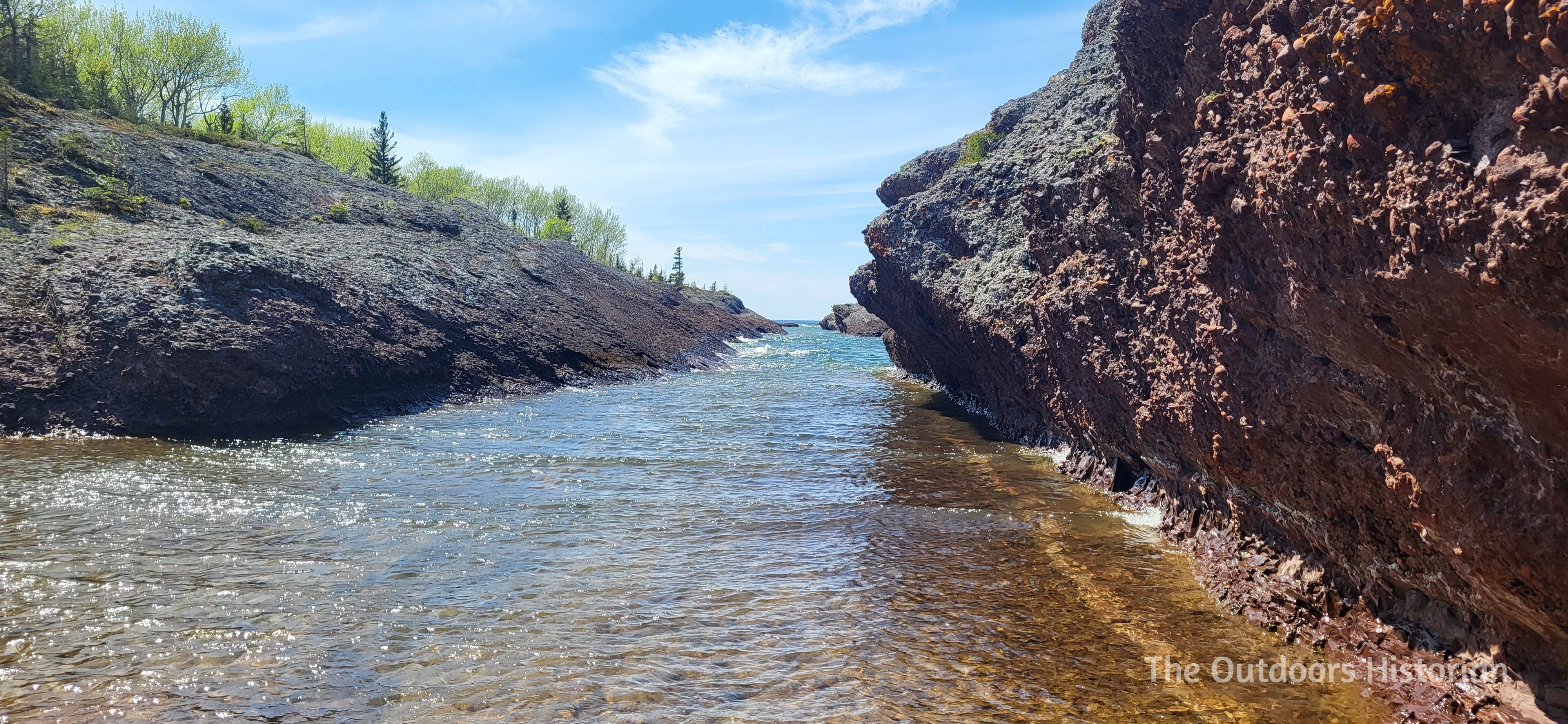
We grabbed our UV flashlights and headed for the shoreline. We walked along the beach, heading east toward where the couple directed us beyond a basalt point. The shoreline got rockier. We had arrived.
This first night was a learning experience. Walking the rocky, unfamiliar shoreline past the point in the pitch black required a different kind of focus. We found a few glowing rocks, or more accurately, pebbles. They were small successes that proved the magic was real, but we were mostly getting our “sea legs,” learning the terrain of the beach.
As we returned to our campsite, the lights of a freighter heading west, probably to the Twin Ports of Superior, Wisconsin and Duluth, Minnesota, or maybe to a smaller port like Two Harbors, Minnesota, interrupted the darkness of the horizon. Since the first lock opened in Sault Ste Marie in 1855, shipping has been the major method of transporting raw materials around the lake. The copper boom was over, but other mining industries persist, including taconite along the Minnesota North Shore of Lake Superior and limestone from Lake Huron.

We decided to call it a night early, resolving to scout the terrain by daylight tomorrow before returning for a serious hunt the next evening. We settled into our tent, moonlight streaming in through windows, lightly illuminating the inside. We listened to the rhythmic waves of Lake Superior, as we drifted to sleep in the crossing place after traveling over layers of history we were only just beginning to explore.
The next morning, we woke up to the glow of a beautiful sunrise. We enjoyed the glittering morning sun and returned to the shoreline to see what we had been walking on. We hiked further than the previous night, thoroughly scoping out the area and enjoying the scenery of the rugged coast and the sound of small waves lapping at the shore.

We also noticed a mountain bike trail that was just inland, up the small bank and in the woods, parallel to the shore. This made it much easier (and quicker) to walk back to the campsite, rather than navigating the rocky beach again. We found a handful of beautiful old white pine along this trail that somehow managed to escape over a century of logging unscathed.

As we crossed over the basalt point, heading back to the beach and our campsite, I paused to reflect on the geology. These volcanic rocks are a humbling reminder of scale; they show us how small our lives are compared to the immensity of geological time.

Hitting the Trails
After soaking in the geology, we swapped hiking boots for tires. When you explore the Keweenaw, you drive across layers of geological history that tell a story more than a billion years old. And the same forces that created copper had left behind a topography that is a premier off-road destination on the American side of Lake Superior.
We stocked up on snacks, hopped in the Tacoma, and backtracked from our campsite through the twisty turns and water crossing to the wider logging roads, eventually taking the turn off to Horseshoe Harbor. We continued past the popular nature preserve, eventually reaching a point where private property lines drew a hard stop. This section of two-track offered a variety of challenges, including a kind of “micro rock crawling” that you rarely find in this region. The highlight—and the challenge—was navigating a series of rocky steps and a deeply rutted, off-camber section that demanded focus behind the wheel. Experienced drivers would consider it no big deal, but it is one of the more technical challenges I have driven, and I was grateful to have Eugene acting as both a spotter and coach.
We also stopped and visited a rocky basalt point that juts north into the lake and a small “dune” made of polished rocks from the lake. From this point, Eugene took over driving, and this means we really tested out the shocks, and they did great. We took a tight, muddy trail over to High Rock Bay and the historic Keweenaw Rocket Range. The road to High Rock Bay ends on a spacious point of dark, hard basalt, which creates a rugged, jagged shoreline east toward the Rocket Range. To the west stretches the cobble beach of High Rock Bay. It is an extremely popular spot for dispersed camping and destination for groups of people riding ATVs and driving SXSs.

At the nearby Rocket Range, we ran into a family in a Jeep whom we had spotted at a rest station and gas station on the drive up, which was another fun moment of connection. The Rocket Range is another interesting historic site. Like High Rock Bay, it is a popular destination for dispersed camping and people driving trails. But between 1964 and 1971, it was one of six launch pads scattered across North America used to collect meteorological data and measure solar X-rays. Today, there is a concrete pad and an engraved stone sign recognizing the site’s history.

It was a great afternoon. But the popularity of High Rock Bay and the Rocket Range was a reminder of why we chose our camping spot. They are beautiful, but busy. Turning the truck back toward Keystone Bay, we felt a wave of relief returning to our sanctuary. It was quieter, secluded, and felt like our own special spot. In fact, we did not even realize there was another vehicle (a Toyota 4Runner!) parked at the opposite end of the bay from us, until I took a walk looking for leaves to put in my dried flower/leaf press.

Surf, Turf, and Stone
As we settled into camp after our adventures, we were hungry for the main event. If the previous night’s fajitas were “glamping,” tonight was pure backcountry luxury.
The menu was steak, lobster, and orzo. We planned this meal when one of Eugene’s friends was planning to join us for our previous trip. The meal was going to be our birthday present to him. We had all the ingredients, so we figured we might as well enjoy the meal ourselves.
We set up a stainless-steel pan over the grate of the campfire, searing the steak and steaming the lobster tails over the wood coals. On the side, I fired up the propane stove to reheat the orzo, stirring in pesto and Boursin cheese for a creamy, herb-filled finish.
There is something primally satisfying about eating a much more gourmet meal than what is available at most of the local restaurants in our area while sitting in a camp chair, smelling woodsmoke and pine. By the time we ate, the light was not great, so I decided to enjoy the moment, rather than trying to get a picture.

With our bellies full, we were ready for the sequel to last night’s hunt. This time, we had a strategy after scouting the terrain by daylight. We returned to the shore, UV lights in hand, and the difference was night and day. The shore lit up with the orange glow of sodalite—hidden fires revealing themselves to us one by one. It was one of the most successful hunts we have had. As we scanned the shoreline in the past, I was reminded that these rocks, born of ancient geological forces, hold secrets of past lives and untold stories.

Crossing Paths With Ghosts
The next morning, we woke up to an even more beautiful sunrise than the previous day. I headed to the point at the end of the bay to get a clearer view.
Then we focused on dismantling our temporary home. Once we were packed up, we headed back to Copper Harbor. We made an overlook in Fort Wilkins State Park to visit one of my favorite signs on Lake Superior about life on the ship the John Jacob Astor and the subsequent wreck after it was caught in a gale and ran aground in September in 1844 when it was making a delivery of supplies to Fort Wilkins. The remains of the Astor lie in about twenty to thirty feet of water and it is the oldest known shipwreck in Lake Superior. I plan to write more about the Astor and the signs at another time, so definitely make sure you are subscribed if you are intrigued as to why I love these signs so much!

We couldn’t leave the northernmost point of the peninsula without one last epic drive—this time on pavement. We drove up Brockway Mountain and stopped at the lookouts to take in the sweep of fall colors. The 9-mile paved road is the highest paved road between the Allegheny Mountains and the Rocky Mountains. The Keweenaw County Road Commission created the road with the help of federal highway funding in the wake of the Great Depression. Most of the laborers were unemployed copper miners. The road was finished in 1935.
We took in the beauty of the lookouts in the fall. Before our eyes, the fall leaves draped the ridges of the Peninsula in a tapestry of golden and crimson maples and oaks mixed with dark green conifers extending around you and running down to the vast blue of Lake Superior.

From that point on, the main adventure was over. We stopped at Keweenaw Coffee in Calumet for coffee and lunch. The return to “real life” from any camping trip gives me mixed feelings. I am sad to leave behind the campsite we made into a home and the adventures we had, but I also get excited by the taste of a hot latte prepared by someone else, and the promise of a warm shower later that night. I also love the area we live in. And I know we will have the opportunity to return to the Keweenaw and make more memories.
We headed south over the Lift Bridge, crossing the Keweenaw Waterway to trace the rocky spine to the base of the Peninsula before turning west. As we left the Keweenaw behind, I thought about the layers of history we passed through and how we were just a tiny blip on this timeline. The lands we traveled were shaped by geological events that happened over a billion years ago. The tire tracks we left in the mud will wash away with the next rain, erasing the remnants of our weekend. They were brief, fleeting markers of our visit.

Yet as I explore the shores, trails, and dirt roads in the crossing place, I sometimes feel like I cross path with ghosts of those long gone, echoes of their impressions etched in the land. Like tire tracks, people are much more ephemeral than the rocks that create the network of trails and roads. And people are also the heart of a place. Seeing people in the present is something we do every day. But seeing people from the past takes intentionality, just like arriving in the Keweenaw. These ghosts are there when I listen closely. Copper miners who arrived when the ice receded. Anishinaabe peoples and fur traders traveling over old portage routes. Remnants of turn of the twentieth century mining communities. The winds we felt throughout our trip whisper of journeys past.

The people who live here in the present deal with the legacy of these ghosts. Some of these legacies are good, like the resilient communities that survive and adapt. However, other legacies illustrate the harm caused by the boom and bust copper industry. Entire beaches have been replaced by stamp sands, which are another form of mining waste which is particular harmful since the small particles are pulled by waves into the lake where they cover the reefs where trout spawn. There are fish advisories for some lakes connected to the Keweenaw Waterway because they high levels of heavy metals levels because copper mining waste, including stamp sands, heavy metals, and other industrial byproducts, were dumped into them for decades. While all people who live in the Copper Country deal with these legacies, they are particularly impactful for Keweenaw Bay Anishinaabe Nation whose ancestors have fed their communities with the fish from these waters long before Europeans arrived.

To explore the Keweenaw is to step into a conversation between the living and the dead, where history’s whispers move on the currents of the wind and are carried into the future. This is a place we visit to touch the past for a moment, to mingle with ghosts as we lose ourselves in exploration and remind ourselves of the bigger picture. On our trips, we continue to see the impacts of the industrial copper boom. Yet we also feel the ancient rocks under our feet and tires, and feel small compared to the immensity of geological time.

Have you visited the Keweenaw? Where are your favorites places to explore? Do you have questions about its history?