More than a View: Reading the Deep Map of Frog Bay
Why the “12th visit” is where the scenery ends and the story begins.

I was in the parking lot at Frog Bay Tribal National Park this spring when I crossed paths with two women who were practically glowing. “It’s our first time here,” they told Eugene and me, eyes wide. “The trail was wet, but it was SO worth it. Have you been here before?”
I smiled and agreed, because they were right and because, yes, we’d definitely been here before. It was fun to see their “first-time high”—the immediate breath-taken-away magic of the old-growth cedars and hemlocks—a necessary gateway. We all need that initial spark to fall in love with a place.
But as I watched them walk toward their car, I thought about the “Twelfth Time” philosophy. The first visit is for the postcard view; the twelfth visit is when the land begins to speak back in multilayered conversation.
To truly see a place, you have to move past the “view.” You have to stop treating the landscape like a postcard and start reading it like a manuscript. This is what I call Landscape Literacy: the ability to see the layers of time, law, and ecology that you don’t seen if you just look at a regular, two-dimensional map.
To practice Landscape Literacy, I’ve developed a Deep Map Methodology for the Lake Superior region. Here’s how you can read the six layers of this method at Frog Bay, a short drive north of Bayfield, Wisconsin in the Red Cliff Reservation.

A short note on accessiblity & facilities
There are no accessible trails at Frog Bay. Visitors can chose to take the Ravine Trail (start by crossing the foot bridge) and doing a loop of approximatley 1.5 miles by connecting to the Beach Trail.
Alternately, you can start on a two-track and head directly toward the beach. If you stay on the two-track, you’ll reach the beach in under half a mile. You’ll also have the option to take a single track trail that splits to the right and heads through a cedar grove, before bringing you to a different section of the beach (and the opportunity to connect to the Ravine Trail).
There are minimal facilities at Frog Bay. The parking lot is gravel and there is an outhouse. Be respectful and pack out any garbage from your visit.
Layer 1: The Ravines of the Rift (Geology)
The story of Frog Bay doesn’t start with a trail map; it starts 1.1 billion years ago with a scar.
Deep under your boots is a remnant of the Midcontinent Rift, a moment in Deep Time (over a billion years ago) when the continent tried to tear itself apart, spewing massive layers of lava to the surface. Eventually, the split failed, but the sheer weight of that cooling lava caused the earth’s crust to sag, creating a vast, bowl-shaped basin. Across hundreds of millions of years, that basin filled with sediment that hardened into the sandstone which is the foundation for the shore we see today.
But the geology here isn’t just about the ‘failed split’; it’s about how the earth breathes. The Bayfield Peninsula is defined by its ravines—deep, dramatic drainage lines scultped by more recent geological events.
Most of these ravines are carved into a 50- to 100-foot-thick ‘mantle’ of glacial till and lake-bed clays. The till was deposited and carved in the last Ice Age (over 11,000 years ago). Because these layers are soft and highly erodible, water can slice through them quickly, creating the steep, V-shaped walls that characterize our coastal plain.
The geology also affects how the earth breathes. Those deep, cool cuts in the clay act as lungs for the landscape, trapping pockets of air that are consistently cooler than the surrounding woods. These micro-climates are what protects the ecological diversity at the heart of this forest.
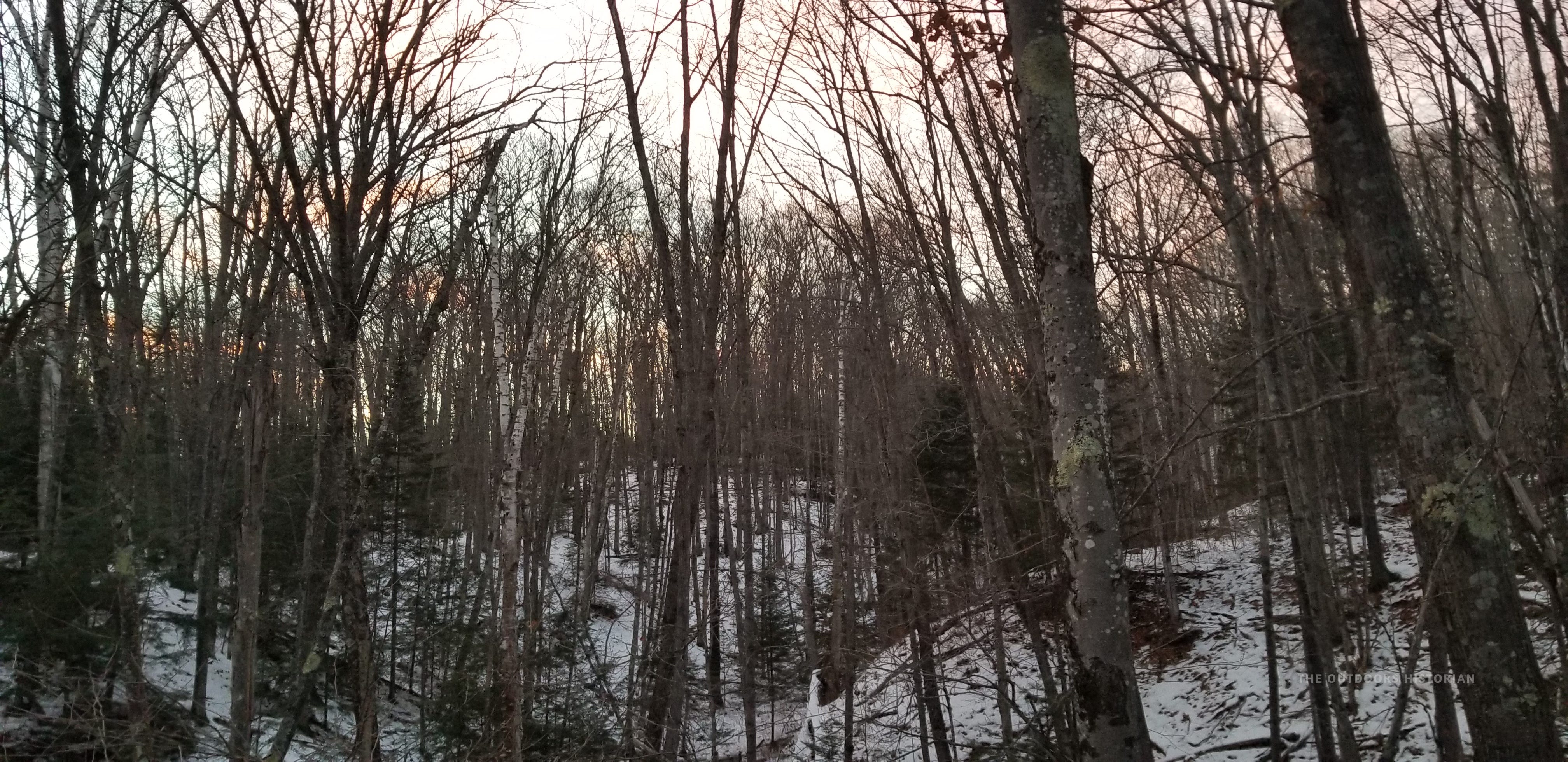
Layer 2: The Boreal Outlier (Ecology)
Frog Bay is a mesic forest (moderate, well-balanced supply of soil moisture) with a mixture of hardwood and conifer species, including oak, maple, and hemlock. Because of that cool air and the proximity to the Big Lake, Frog Bay also has pockets of forest with stronger boreal elements than you’ll find in the surrounding region, including species like spruce and birch.
One of the foundational species of this forest is the Giizhik—Northern White Cedars. They rise along the side of the trail, like old guardians of the land. The roots of cedar and other trees wrap around the soil and stones under the surface, like a web, helping to hold the earth together and prevent erosion.
When you look closer, you’ll see the “nurse logs.” These are fallen ancestors that have become mossy cradles for new growth. In ecology, death isn’t an end; it’s a regeneration. This cyclical nature is the pulse of the forest, but it’s also a mirror for human history. These trees are living archives; they have witnessed every legal and social shift this shoreline has endured. They are the living connection between generations and our present moment.


Layer 3: Indigenous Peoples and Sovereignty
This is the layer that explores who has accessed this land, who has claimed ownership of this land, and who has stewarded this land.
Anishinaabe people have lived along these shores for millennia.
Then, with the Treaty of 1842 (also known as the Copper Treaty), the Anishinaabe ceded the territory to the United States but reserved their usufructuary rights to hunt, fish, and gather on ceded territory. They were protecting a relationship with the landscape that a legal deed could never fully capture.
The Treaty of La Pointe in 1854 added a new, more localized layer. While this treaty established reservations, it was also an assertion of presence. Chief Bizhikii (Buffalo) and his community were determined to remain specifically on the Bayfield Peninsula. While communites in places like Odanah grews as state and local officials drove Anishinaabe people onto reservations in the decades following the treaty, Bizhikii fought for the right to stay here, on this specific ground. Before the treaty was signed, he famously traveled to Washington D.C. to ensure his people would not be removed from the shores they had stewarded for generations.
However, the 1854 treaty also introduced a legal mechanism that would fracture the map: Allotment. By carving tribal land into individual, “owned” fee simple parcels, the government created a path for land to slip away. Over decades, through complex and often predatory real estate maneuvers, these allotments were transferred into the hands of settlers. This is how the “Deep Map” became a checkerboard of private “No Trespassing” signs, and how this specific stretch of shoreline became a private estate for nearly a century.
The story didn’t end in privatization, though. When the last private landowner passed away, they left the land to a local conservancy. Recognizing the deeper history of the soil, the conservancy worked with the Red Cliff Anishinaabe Nation to repatriate the land.
This wasn’t just a land transfer; it was a strengthening of sovereignty. The creation of Frog Bay Tribal National Park—the first of its kind in the country—restored the Human Layer of the map to its rightful stewards. When you look at the boundary of the park today, you aren't just looking at a property line; you're looking at a hard-won victory against a century of legal erasure—a physical map finally realigned with its true story.


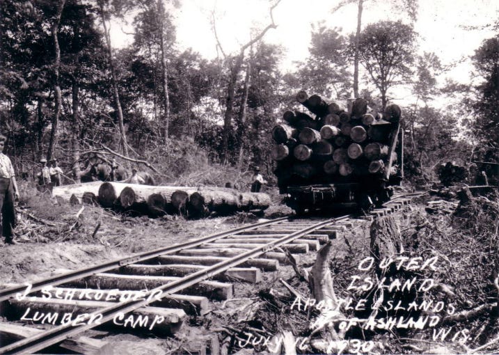
Layer 4: Extraction
This is where the ‘Deep Map’ reveals a stark contrast. When you stand on the protected, un-cut shore of Frog Bay and look out toward the Apostle Islands, you are looking across a blue highway at two entirely different ecological and industrial histories.
In contrast to Frog Bay, the islands bear many scars of 19th-century extraction. Most of the islands were heavily logged during the Cutover Era that followed land cession treaties. They were also mined for their Brownstone, which is the same red sandstone that built the iconic “Brownstones” of Chicago and New York.
Federal officials were reluctant to make this heavily scarred landscape a national park in the early twentieth century. However, by 1970, the industry had subsided, opinions changed, and the Apostle Islands were transformed once again—this time from a site of extraction to a National Lakeshore managed by the National Parks Service. This move strengthened the growing tourist sector in the region. Since the late nineteenth century, wealthy residents of the southern Midwest headed north in the summer to experience the cool Lake Superior air and beauty of the landscape (Nebraska Row in the Town of La Pointe on Madeline Island was established at this time).
The creation of the Apostle Islands National Lakeshore also undermined Anishinaabe sovereignty. In 1986, an act of Congress included part of Long Island in the National Lakeshore. In the mid-1970s, sand connected the island to Chequamegon Point. The eastern border of the park’s lands on Long Island abuts the Bad River Nation (whose reservation extends east of Ashland and encompasses Chequamegon Point).
Bad River Band of Lake Superior Chippewa claims ownership of Long Island, and trace their claims back to the Treaty of La Pointe in 1854, which established the Bad River Reservation boundaries as extending along the lakeshore and across Chequamegon Point. You can read more about this dispute on the Cheqauemgon History blog, which is a fantastic source for the history of our region. This is also an example of the complicated history of public lands in North America, and how their creation is often fundamentally tied to the dispossession of Indigenous peoples from their lands.
Layer 5: Maritime History
When you look out at the islands, the lighthouses on Raspberry or Michigan Island are hidden by the horizon from this beach. However, even though you can’t see them, their presence defines this water. They are the invisible anchors of a maritime highway. During the Cutover and Brownstone Era in the late nineteenth and early twentieth century, there was an industrial highway weaving between the islands. The lighthouse was a witness to the transition from Indigenous trade routes to the industrial shipping that fueled the growth of the Midwest.
It is a profound contrast: today, you might see signs of recreational motorboats or sailboats, or even boat tours. But this was once a crowded, soot-stained industrial highway. Knowing those lights are out there, even when they are invisible, reminds us that the stillness of this beach is a relatively new chapter in a long, loud history of extraction and rescue.
When you visit today, take a moment and close your eyes. Use all your senses. What do you hear? What do you smell? What do you taste? What do you feel? Then open your eyes and take in the present.
Now, close your eyes again and visualize a different historical era. Think about your senses again. Would you hear the rhythmic thud of a steamship engine, or the snapping canvas of a schooner like the Lucerne struggling against a November gale before wrecking off the ice-coated shores of Long Island? Would you smell the sharp scent of fresh-cut pine or heavy coal smoke? How does the “taste” of the air change when it’s filtered through a modern forest versus a soot-stained industrial harbor?
Now, push back even further. Think about what this shoreline felt like in the year 1600—an era of seasonal rounds, deep Anishinaabe diplomacy, and a forest that had never heard the ring of a crosscut saw.
What do your insights tell you about the history? How will your insights inform your actions when you leave this place?

Layer 6: The Act of Walking (Stewardship)
Stewardship isn’t just a feeling we have while looking at a sunset; it’s an informed responsibility to the layers of the landscape. When you stand on that beach now, you aren’t just looking at the water. You are standing on land that was retained by Chief Bizhikii for his people, fractured by allotment, and finally brought home.
Knowing this history changes how you walk the trail. It turns a “hike” into a conversation with layers of history. But for this conversation to mean something, it must move from your head to your feet. Stewardship means that once you see the layers of a place, you can no longer ignore them. It informs your actions long after you leave the trail—shaping how you advocate for the shoreline, the forest, and the stories revealed by the ‘Deep Map’ rather than just consuming a view and moving on.
This is the transformation that happens when you engage with the Deep Map Methodology: you stop being a guest of the landscape and start building an actual relationship with it—one that extends far beyond the drive home.

Seeking the Deep Map
History is complex. Navigating that complexity and reading the landscape is what it means to be an intentional and sustainable explorer. It’s not about finding a “hidden gem” for an Instagram photo; it’s about engaging with the “Deep Map.”

That’s why I use the methodology I demonstrated in this post to look at the northern Great Lakes through six interconnected layers:
The Architecture of the Land (Geology)
The Deep Green (Forest Ecology & Natural History)
Sovereign Stories (Indigenous Peoples, Nations, and Stewardship)
The Industries of Extraction (Logging & Mining)
Maritime History (Shipping, Shipwrecks & The Network of Rescue)
From Spectator to Steward (Memory, Lived Experience, & Action)
Keep an eye on your inbox next week, because I’ve mapped out a brand-new, free 3-Day Bayfield Itinerary designed to introduce you to the landscape through this lens.
Have you visited Frog Bay Tribal National Park? Which layer(s) stood out most to you? Comment below and share!
P.S. I love helping explorers plan meaningful trips in the northern Great Lakes. If you’re looking for tips on how to engage with the “Deep Map” on your next adventure, I offer a limited number of 1-hour strategy sessions each month. If you’re interested, send me a message!
I had the great luck to visit Frog Bay (again) a few days after this was posted. I didn’t think it was possible to love Frog Bay more than I did, but I do. The knowledge and wisdom that Emily shared has taken my appreciation for this gem to a whole new level. Thanks!!!!
This is so great! Very useful and insightful framings. Thank you!