3 Things Most People Miss on a Lake Superior Circle Tour (And How to Find Them)
Moving Beyond the Postcard by Reading the "Stacked Layers" of the Greatest Lake.

For many, the Lake Superior Circle Tour is a bucket-list achievement—1,300 miles of rugged shoreline, golden beaches, and that impossible, ocean-like blue. We pack our cameras, mark the famous overlooks, and prepare for a collection of “pretty views.”
But, have you ever stood at an overlook and felt like you were missing the real story? Usually, that's because we are only trained to see the top layer. We are spectators at a grand performance, admiring the scenery without ever being invited backstage.
Delving into the “Deep Map” of the lake requires a different kind of effort. It asks us to look past the aesthetic beauty and grapple with the harder, often invisible threads of geology, sovereignty, and industrial legacy. It is hard work, but the reward is profound: the landscape stops being a backdrop and starts being a conversation. When you learn to read these layers, you move from “collecting views” to developing landscape literacy. A rock isn’t just a rock; it’s the volcanic plumbing of a continent. A “ghost town” isn’t just a ruin; it’s a physical record of human ambition and extraction.
By doing the work to see these layers, you gain something a “pretty view” can’t offer: a deep, unshakable sense of place. Imagine standing on the shore and not just seeing the water, but understanding your own relationship to the history beneath your boots. You aren’t just passing through the Northwoods; you are beginning to develop a relationship with it.
Whether you’re planning a full 1,300-mile loop or focusing on a single state park, here are the three critical layers most people overlook—and how you can include them on your own itinerary.
1. Indigenous Landscapes: Sovereignty & Stewardship
Most travelers see the Northwoods as a “pristine wilderness.” But there is no such thing as an empty landscape. Since the glaciers receded, Indigenous peoples have lived in and shaped the region. Ancient copper mines in the Keweenaw and on Isle Royale are a testament to this deep presence.
Today, every mile of Big Lake’s shore is Anishinaabewaki—the ancestral and contemporary home of Anishinaabe peoples and their nations. Many parts of the lake have also been (and in some cases continue to be) home to Indigenous peoples from other nations including the Cree, Dakota, Menominee, and Wendat/Wyandot.
What people miss: They see the state park signs and the scenic turnouts, but they miss the historical impact of Indigenous peoples. They also miss the ongoing political and economic power of Anishinaabe Nations in the watershed. They miss the fact that the “pristine wilderness” they are enjoying is a managed, lived-in territory that continues to be a site of sacred ceremonies and political structures, like treaty rights.

As you travel around the lake, you are on ceded territory: land that was transferred from the Anishinaabe to the United States and Canada through land cession treaties in the mid-nineteenth century. The only time you aren’t on ceded territory is when you are on a reservation (in the United States) or a reserve (in Canada); these are areas still under the legal jurisdiction of Anishinaabe Nations.
As with most complex parts of history, there are exceptions. In the United States, allotment and other historical processes created a “checkerboard” pattern of land ownership that within a reservation creates a mix of land that is under legal jurisdiction of the Anishinaabe Nation and private property.
On both sides of the border, Anishinaabe peoples retained “usufructuary rights,” or the right to hunt, fish, and gather on ceded territory. These are also known as “treaty rights.” For over a hundred years after treaties were signed, state and provincial authorities usually ignored these rights and arrested (and in some cases, killed) Anishinaabe peoples for hunting and fishing off-reservation.
In the 1960s, Anishinaabe people began asserting their treaty rights off-reservation, and when they were arrested, they launched successful legal battles. So, when you see a truck at a boat launch with a tribal plate, or see a family harvesting wild rice or fishing, you aren’t just seeing ‘recreation’—you are seeing the active exercise of a 180-year-old international agreement between sovereign nations.
How to look past the erasure:
Research the history of the treaties in 1836, 1842, 1850, and 1854 that shaped the watershed.
Look up maps with Anishinaabe place names produced by organizations like the Great Lakes Indian Fish and Wildlife Commission (GLIFWC) to see the land through a different lens.
Read fiction and history written by Anishinaabe people. Louise Erdrich’s Tracks and Basil Johnston’s work are essential starting points.
Regardless of where you are on the shore, don’t just look at the water—engage with the names, the stories, and the sovereignty of the people who have stewarded this coast for millennia.
, explaining changes to the grounds of the site to work with tribal nations and be more historically accurate.")
2. The Deep Time “Plumbing”
We often marvel at the variety of the lake’s edges—the jagged Sawtooth Mountains of Minnesota versus the flat-topped mesas of Ontario (like the Sleeping Giant). To the casual observer, they look like different "scenery." To the Deep Mapper, they reveal the earth's skeletal remains.
What people miss: They miss the layer of geology that dictates exactly where we can build, where we can hike, and where the water flows.
The Canadian Shield: This is the foundation: a massive, 2-million-square-mile geological region covering nearly half of Canada, spanning from the Arctic to the Great Lakes, featuring ancient, exposed Precambrian bedrock. It is characterized by thin soil, exposed rock, thousands of lakes, and boreal forests. It is also exceptionally rich in mineral resources. Most visible at Pukaskwa, Lake Superior Provincial Park, parts of the UP (like Sugarloaf Mountain by Marquette).
The Midcontinental Rift: 1.1 billion years ago, magma was pushing toward the surface. In Minnesota, it reached the sky and cooled into the jagged ridges we see today. In Ontario, it stayed hidden within older foundations, cooling into the massive, flat “sills” that created the mesas. In other areas, sandstone was created in the base of the rift (Jacobsville Sandstone), visible in places like the Apostle Islands and the Keweenaw Peninsula. This billion-year-old sandstone later became the building blocks of Midwestern “brownstone” buildings in cities like Milwaukee and Chicago. Most visible at the Sawtooth Mountains, mesas in Northwestern Ontario (from border to Kama Cliffs region), Isle Royale, and the Keweenaw Peninsula.
Glaciation: The “landscaping” that occurred as glaciers slowly receded 18,000 to 10,000 years ago. Keep in mind that glaciers are very recent when we think of a geological timeline stretching back billions of years. The entire watershed was sculpted by glaciation.
 on the shore of Lake Superior. The rock layers are visibly tilted toward the water, showing ancient geological movement.")
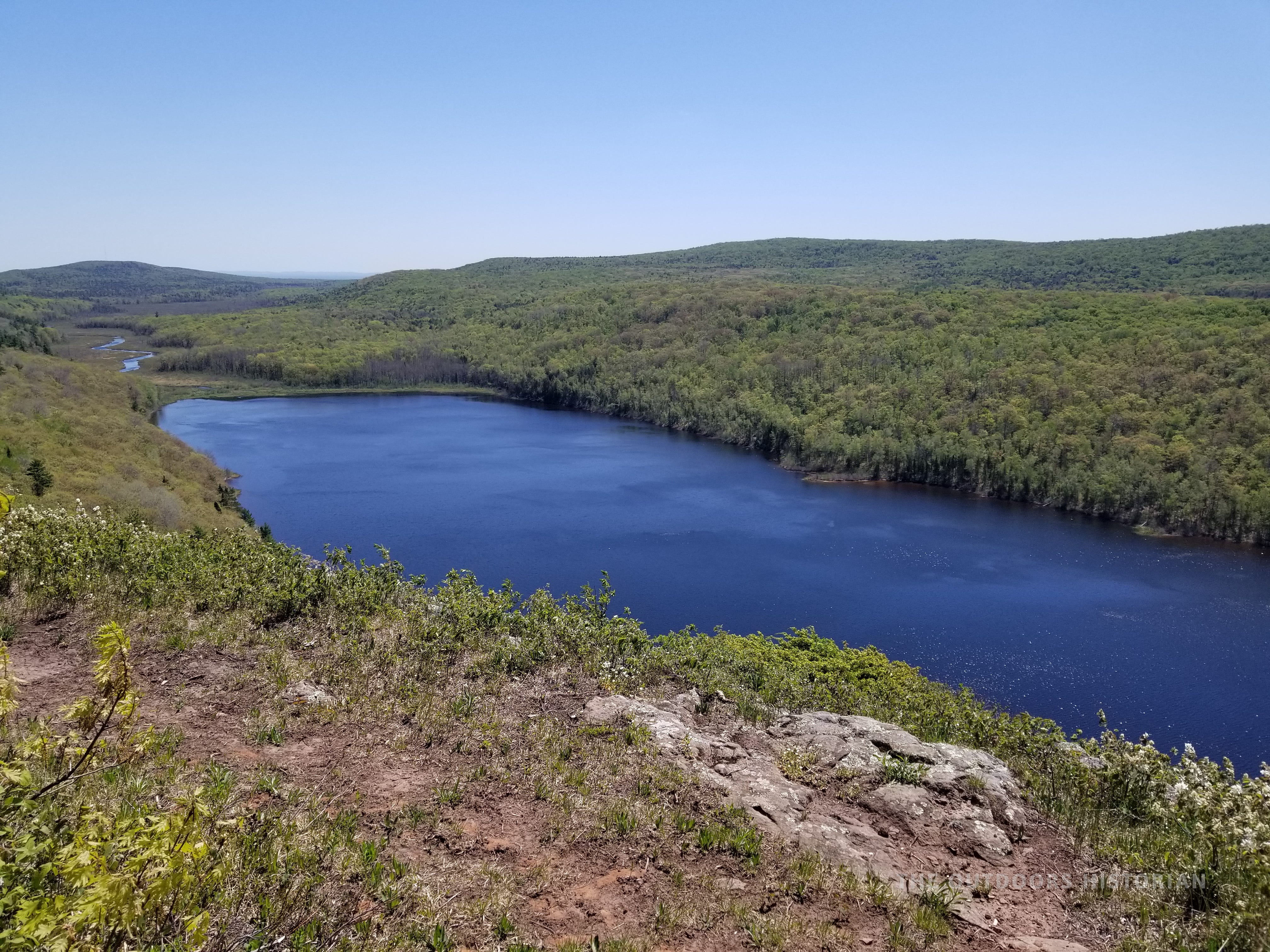
Most areas are a combination of these layers. For example, Lake of the Clouds in Porcupine Mountains State Park is a glacial lake formed between two ridges of basalt and conglomerate formed by the Midcontinent Rift. The glacier eroded softer layers of shale and sandstone, leaving behind the lake basin.
The Historian’s Fix: Think of the landscape as having a foundation (the Canadian Shield), a subterranean “plumbing system” (the MCR), and a giant sculptor (glaciation). When you understand how these layers fit together, the view from the overlook becomes a 3D history of the planet.
3. Industrial Underpinnings at Scenic Sites
It is tempting to think that “Deep History” is only found at the end of a rugged two-track or a ten-mile hike. We often assume that if a place has a paved parking lot and a gift shop, the story has already been told.
What people miss: They see the “Scenic Highlight” but miss the industrial infrastructure. They see a beautiful waterfall or a dramatic sand dune and assume it has always been a site of “leisure.” They miss the fact that many of our favorite state and provincial parks were once the busiest, loudest, and most transformative industrial sites on the continent.


The Historian’s Fix: You don’t need a 4WD vehicle to find the Deep Map. You just need to know what to look for at the lake’s most popular stops. Often, these are former industrial sites.
The Log Slide (Pictured Rocks): As you take in the grandeur of the dunes, remember, you are looking at a site of massive labor. This was an “extraction chute” where old-growth white pine plummeted down to the lake to be rafted to mills. It’s a site of environmental change hidden in a “scenic” landscape.
High Falls (Pigeon River/Grand Portage): Travelers stop here for the “highest waterfall in Minnesota.” As a historian, I see the layers of history. For millennia, this waterfall was a barrier to paddlers; by the mid-nineteenth century, it became an international border and served as a key route for the timber industry.
Split Rock Lighthouse: People see the most photographed lighthouse in the world. This site exists because the iron ore industry demanded it after a catastrophic 1905 storm. Today lighthouses are iconic structures, but it’s also important to remember they were nodes in a systemic grid designed to protect the flow of wealth from the mines to the mills. Sites like Split Rock also highlight the exceptional labor of sailors and lighthouse keepers who took part in the ‘Network of Rescue.’
Whether you are on a five-minute boardwalk or a five-day backcountry trek, look for worn portage paths, the rusted iron, the squared-off timbers, and the “unnatural” levels in the landscape. These aren’t just remnants or ruins; they are the blueprints of how we have related to this lake for the last two centuries.
Remember, in many cases, you don’t even need to get your boots muddy to find the Deep Map. It is accessible to anyone willing to look past the postcard view and start doing the work of reading the landscape.


From Spectator to Steward
The work of the historian is to provide the context that turns a spectator into a steward. A spectator consumes a landscape—taking the photo, checking the box, and moving on. A steward, however, begins to cultivate a relationship with it.
When you begin to see these connections—between the cooling magma, the legal weight of a treaty, and the imprint of an extraction chute—you develop a deeper relationship with the land. You stop just “driving the loop” and start participating in the life of the lake. You aren’t just visiting a “pristine” wilderness; you are engaging with a lived-in, storied territory that demands our respect and our memory.
These three shifts in perspective are just the beginning. In my next post, I’ll be sharing the full 6 Layers of the Deep Map—the methodology I use to turn every northern Great Lakes road trip into an intentional experience.

Of the three layers we covered today—Indigenous Landscapes, Deep Time Plumbing, or Industrial Infrastructure—which one do you think will be most influential on your next road trip? Let me know in the comments or send me a message!
Ready to Plan Your Own “Deep Map” Journey?
I’ve developed two tools to help you navigate these layers with intention:
Download the Free 2026 Lake Superior Circle Tour Planner: This 5-step guide will help you manage the logistics and intention of your trip.
Get the Circle Tour Field Guide: For the full “Deep Map” experience, grab the digital e-book. It’s the comprehensive guide to the 6 Layers of the Lake, featuring curated 8, 10, 14, and 21-day itineraries, tips on how to learn to “read the landscape” at your stops, and checklists and strategies to help you prepare efficiently.
Get the Field-Tested Menu: Planning to camp on your Deep Map adventure? Get my stress-free, fresh-forward, customizable 3-night camping meal plan, including a printable grocery list.
P.S. I’m currently deep in the digital archives, pulling together a curated library of some of my favorite, accessible maps, books, and records to 'read' the Northwoods landscape. It’s almost ready to share with you. I can’t wait to show you what’s inside.